DATE: August 19, 2024
TO: Kevin Davis, Town of Sharon
FROM: Kyle Casiglio, Boston Region MPO
RE: Community Transportation Technical Assistance (CTTA) Program: Intersection Redesign in Sharon
This memorandum describes the results of a transportation study at the intersection of Massapoag Avenue, Pond Street, Quincy Street, and East Street in Sharon, Massachusetts. The study was conducted through the Boston Region Metropolitan Planning Organization’s (MPO) Community Transportation Technical Assistance (CTTA) Program, through which MPO staff provide technical analysis and support to municipalities in the Boston metropolitan area about local multimodal transportation issues.
The Town of Sharon contacted Central Transportation Planning Staff (CTPS), the staff to the MPO, regarding recommendations for redesigning the intersection. The Town requested that MPO staff study the conditions at the intersection and the consequent safety implications. The Town also shared two proposed intersection designs for evaluation.
MPO staff conducted community engagement and collected data to better understand the concerns about this intersection. We conducted a site visit, met with Town staff, and consulted with a representative of the school district. Alongside this outreach, we also analyzed traffic counts, turning movement counts, speed data, and crash records to assess the concerns at the intersection, evaluate the two alternative designs, and develop recommendations.
Our recommendations focus on improving safety for all road users by reducing high-speed traffic, providing safe facilities for pedestrians and bicyclists, and reducing risky merging and turn maneuvers.
It is worth noting that this intersection was included in the 2014 Lake Massapoag Bicycle Network Plan prepared for the Town of Sharon by the Metropolitan Area Planning Council (MAPC). The plan recommended a dedicated bike lane in the northbound direction from the Easton town line through the intersection and on to Depot Street, as well as shared lane markings for the southbound direction.
Study Area
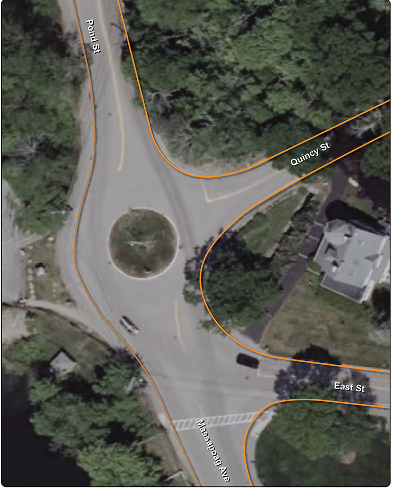
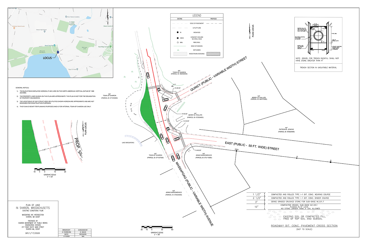
The study intersection is located in the Town of Sharon, which is a member of the Three Rivers Interlocal Council (TRIC) subregion in the Boston metropolitan area. (See Figure 1.) Sharon is home to robust natural resources, including Lake Massapoag, which is one of the source waters of the Neponset River and abuts the study area. The population of Sharon is 18,408 based on the five-year 2018-2022 American Community Survey (ACS) estimates.
Massapoag Avenue and Pond Street are rural minor collectors that carry local traffic north and south between low density residential neighborhoods in the southern section of Sharon and the northern portion of town where Sharon High School and downtown Sharon are located. Pond Street feeds into State Route 27 at its northern end, facilitating access to Interstate 95, Sharon Station on the MBTA commuter rail’s Providence Line, and neighboring towns to the north and east.
The study area contains two intersections that in practice act as one. The intersection of Massapoag Avenue, Pond Street, and Quincy Street is controlled by a traffic circle. Drivers approaching from Quincy Street do not have yield access to the traffic circle and must stop before entering. Drivers approaching from Massapoag Avenue or Pond Street have a speed limit of 35 miles per hour (mph).
Approximately 50 feet to the south of this intersection is the intersection of Massapoag Avenue and East Street, which is a “T” intersection. Drivers approaching via East Street must stop before turning either left or right onto Massapoag Avenue. Turning right forces these drivers to then enter the traffic circle.
The proximity of these intersections creates a situation ripe for traffic conflict. Drivers exiting the traffic circle southbound onto Massapoag Avenue frequently make a subsequent left turn onto East Street. When this maneuver coincides with northbound vehicles traveling through the intersection on Massapoag Avenue, the proximity of the two intersections creates confusion over which driver should yield the right-of-way. While it is the responsibility of the driver turning left to yield to the northbound driver, this confusion is exacerbated by the presence of a MA-R1-11 “State Law Yield To Traffic In Rotary” sign posted at the intersection of Massapoag Avenue and East Street.
Figure 1 – Study Area
Community Engagement
Kickoff Meeting
MPO staff met with Kevin Davis, Assistant Town Engineer from the Town of Sharon, on Monday, January 25, 2024. Mr. Davis outlined the concerns Town staff had observed at the intersection and shared two alternative designs that municipal staff had developed. Mr. Davis coordinated between municipal and MPO staff to arrange a site visit.
Site Visit
MPO staff met with Sonal Pai, Planning/Engineering Specialist, and Danica Cucchi, GIS Coordinator, from the Town of Sharon on Monday, January 29, 2024. The visit took place from 2:30 PM to 3:30 PM to coincide with the release of the nearby Sharon High School and Sharon Middle School, when traffic through the intersection reaches a peak. A walk-through of each intersection was conducted. We took photographs of existing conditions and observed drivers utilizing each intersection. We also discussed issues and concerns with Ms. Pai and Ms. Cucchi.
Site Visit Findings
MPO staff observed and noted existing conditions of the facilities at each intersection:
- Frequent speeding was observed by people traveling southbound from Pond Street to Massapoag Avenue.
- Conflict between people attempting to turn left onto East Street after exiting the traffic circle and those traveling northbound on Massapoag was very common. More often than not, people traveling northbound would yield to those turning left. Oftentimes both people stopped their vehicles, unsure of who was supposed to yield to whom. (See Figure 2.)
- There is a trailhead with a kiosk in between Pond Street and Quincy Street marking an entrance to Massapoag Trail, a 5.4 mile trail that follows Massapoag Brook from the Hixson Farm development in East Sharon to Lake Massapoag. As there are no sidewalks or crosswalks facilitating the approach to this trailhead, there is no safe way for hikers to cross from the trailhead to the lake. (See Figure 3.)
- Very few people driving vehicles utilized Quincy Street.
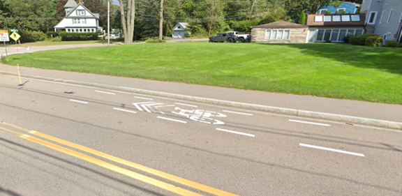
- Recommendations of the 2014 Lake Massapoag Bicycle Network Plan have been partially implemented. Shared lane markings exist in both directions south of the intersection, as does a “Share the Road” sign located in the intersection facing southbound traffic. However, markings are absent north of the intersection, and dedicated bike lanes have not been established. (See Figure 4.)
Figure 2
View of Conflict Point from Corner of East Street and Massapoag Avenue
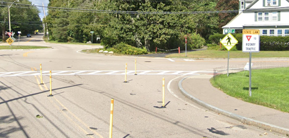
Source: Google Street View (September 2023).
Figure 3
Massapoag Trail Trailhead
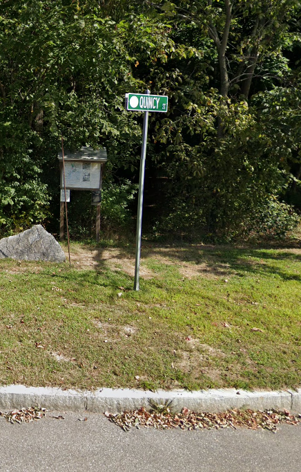
Source: Google Street View (September 20219).
Figure 4
Shared Lane Markings South of Intersection
Source: Google Street View (September 2023).
School District Staff Interview
MPO staff spoke with Fran Derry, Supervisor of Transportation for Sharon Public Schools, on April 24, 2024. Ms. Derry explained that the schools had used the rotary as a turnaround for buses in the past, but this was no longer the case. Ms. Derry reiterated concerns expressed by other municipal staff that traffic backs up at the intersection during school pick-up and drop-off hours. She attributed this traffic in part to the close start times of the high school and middle school, when vehicles traveling to both schools pass through the intersection simultaneously. Ms. Derry also expressed concerns about the left-turn conflicts that take place as people exit the traffic circle and turn onto East Street.
Existing Conditions Analysis
To examine the existing conditions, MPO staff collected automatic traffic recorder (ATR) counts on the approaching roadways and intersection turning movement counts (TMCs) for this study. The ATR counts were performed during January 30 to February 2, 2024 (Tuesday–Friday). The TMCs were collected on Wednesday, January 31, 2024, during the morning peak period (6:00 AM to 9:00 AM) and the evening peak period (3:00 PM to 6:00 PM).
Daily Traffic Volumes
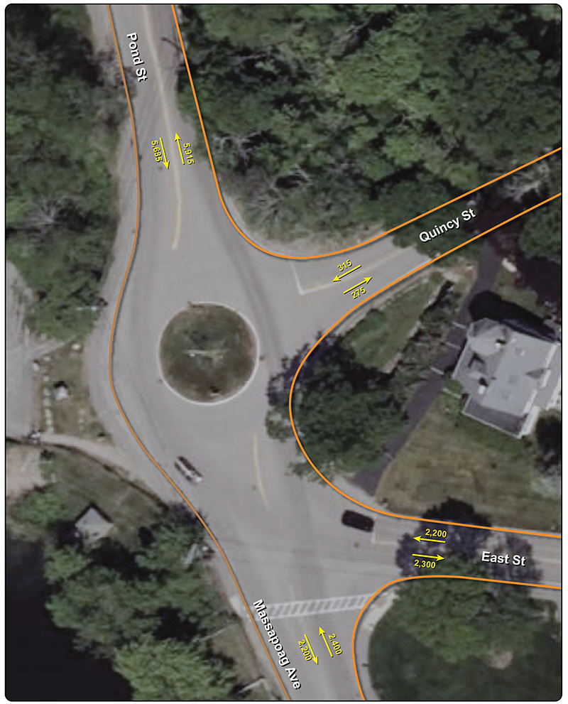
Figure 5 below summarizes the average annual weekday traffic volumes. Based on the data, we estimated the average weekday traffic volumes in roadway sections near the study intersections as follows:
- Pond Street, north of intersection—11,600 vehicles, with a split of 5,915 (51 percent) northbound vehicles and 5,685 (49 percent) southbound vehicles
- Massapoag Avenue, south of intersection—4,600 vehicles, with a split of 2,400 (52 percent) northbound vehicles and 2,200 (48 percent) southbound vehicles
- East Street, southeast of intersection—4,500 vehicles, with a split of 2,300 (51 percent) southeast-bound vehicles and 2,200 (49 percent) northwest-bound vehicles
- Quincy Street, northeast of intersection—590 vehicles, with a split of 275 (47 percent) northeast-bound vehicles and 315 (53 percent) southwest-bound vehicles
Full ATR count data can be found in Appendix A of this memo.
Figure 5 – ATR Counts
Turning Movement Counts
MPO staff collected turning movement counts at the study intersections on Wednesday, January 31, 2024, during the morning peak period (6:00 AM to 9:00 AM) and the evening peak period (3:00 PM to 6:00 PM).
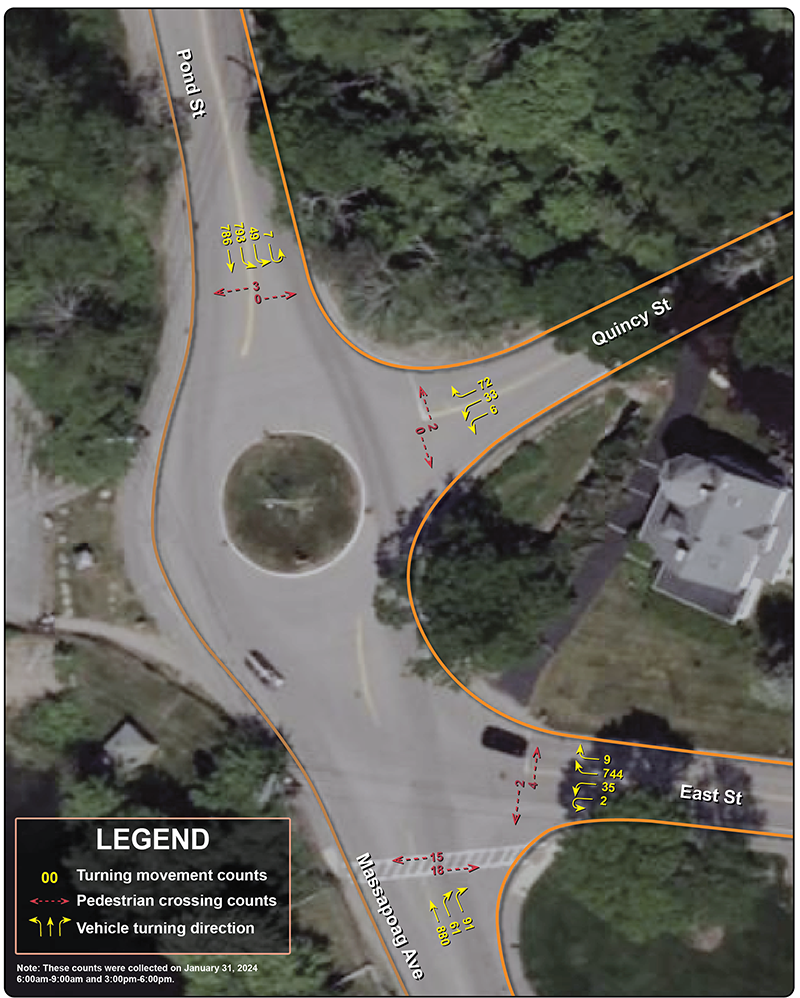
Figure 6 summarizes the January 31, 2024, AM and PM peak-hour traffic turning volumes. The primary routes utilizing this intersection are between Pond Street and Massapoag Avenue, and between Pond Street and East Street. Original TMC count diagrams can be found in Appendix B of this memo.
Figure 6 – TMCs
Safety Concerns
MPO staff utilized the Massachusetts Department of Transportation’s IMPACT Crash Portal1 to determine the crash rate and number of crashes involving vulnerable road users2 at each intersection over the five-year period from 2019 to 2023. One crash was recorded in the study area during this five-year period. On June 11, 2020, at 8:02 PM, a person driving southbound on Massapoag Avenue struck the curb and fence approximately ten feet south of the intersection of Massapoag Avenue and East Street. No crashes occurred in the traffic circle during the five-year period, and no vulnerable road users were involved in crashes in either intersection. This crash data was verified by Town staff using Sharon Police Department records.
Several safety-related issues were identified by municipal and MPO staff. Notable issues identified included frequency of speeding, left turn conflicts, lack of pedestrian facilities on the eastern side, and lack of bicycle facilities.
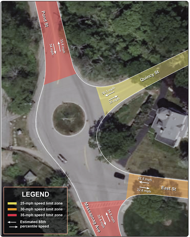
Figure 7 shows 85th percentile speed data for each of the approaches to the intersection. Drivers on Pond Street and Massapoag Avenue typically drive at or below the speed limit. Drivers on East Street have an 85th percentile speed slightly above the speed limit, while drivers on Quincy Street have an 85th percentile speed concerningly high above the speed limit (exceeding it by at least 10 mph). It should be noted that the speed limit within the intersection itself is 25 mph. MPO and Town staff observed drivers frequently failing to slow their vehicles from the approaching roadway’s speed limit to the intersection’s speed limit. Full speed data can be found in Appendix C of this memo.
Figure 7 – Speed Data
Alternatives Analysis
Town of Sharon staff shared two alternative designs for the intersection. MPO staff evaluated the pros and cons of each design and made recommendations to address the concerns with each. We did not select a preferred alternative or consider a “no-build” alternative.
Design Alternative 1
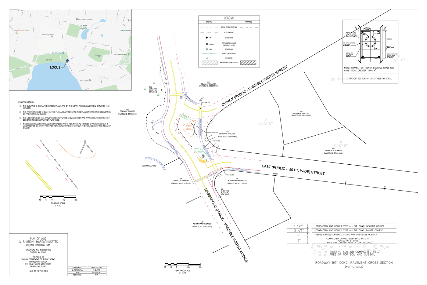
Design Alternative 1, shown below in Figure 8, would remove the traffic circle and straighten out Pond Street and Massapoag Avenue. A portion of the right-of-way along the western boundary would be converted into green space adjoining the existing Massapoag Beach parking lot. Another portion would be used to create a second southbound lane through the intersection in which people turning left onto East Street could queue. The approaches from Quincy Street and East Street both would remain stop sign-controlled with slip lanes added for right hand turns. Crosswalks are proposed to be added to the East Street, Quincy Street, and Pond Street approaches to the intersection. A sidewalk is proposed to be added to the eastern portion of the intersection, between East and Quincy Streets and between Quincy and Pond Streets.
We noted the following for Alternative 1:
Pros:
- Eliminates the left turn conflict that was observed to cause significant stress at the intersection
- Expands pedestrian facilities in the intersection
- Establishes safe and legal access to the Massapoag Trailhead where none presently exists
Cons:
- Removes the traffic-calming element by straightening the right-of-way and widening the southbound roadway to two lanes—These changes will quite likely encourage drivers to travel through the intersection at higher speeds.
- Introduces slip lanes that, as designed, facilitate fast speeds through the intersection—Quincy Street, which was found to already have an 85th percentile speed well above the speed limit, is of particular concern.
- Forces pedestrians to go out of their way to legally and safely cross the street because of the placement of the crosswalk on Quincy Street
- Does not protect the pedestrian crossing on Pond Street where there would be high traffic volumes and anticipated higher-than-baseline vehicle speeds
- Does not provide bicycle facilities through the intersection
Figure 8
Design Alternative 1
Massapoag Avenue and Pond Street at East Street and Quincy Street in Sharon
Source: Sharon Department of Public Works.(September 2023).
Design Alternative 2
Design Alternative 2, shown below in Figure 9, would remove the traffic circle and replace its traffic-calming effects by creating a large, sloped bump-out of the eastern curb. Both northbound and southbound traffic on Massapoag Avenue and Pond Street would navigate a curve at the location of the present traffic circle. The bump-out would, however, extend much further south than the current traffic circle, straightening out the turning maneuvers between East Street and Massapoag Avenue. Approaches from the side streets would remain stop-controlled. This alternative includes sidewalks and crosswalks for the eastern portion of the intersection. The design also includes a bump-out at the intersection of Massapoag Avenue and East Street’s southern corner. Green space added by the design would be used for greenery and public amenities.
We noted the following for Alternative 2:
Pros:
- Eliminates the left turn conflict that was observed to cause significant stress at the intersection
- Improves pedestrian facilities in the intersection
- Enhances existing pedestrian facilities via bump outs
- Establishes safe and legal access to the Massapoag Trailhead where none presently exists
- Maintains traffic-calming elements in the intersection despite removal of the traffic circle
Cons:
- Reconfigures geometry and introduces foliage and a recreational amenity that raises significant concerns about lines of sight for people turning off side streets, particularly Quincy Street
- May cause delay for southbound drivers at school drop-off and pick-up time as they will have to queue behind drivers turning left onto East Street
- Forces pedestrians to go out of their way in order to legally and safely cross Quincy Street due to the crosswalk location
- Does not protect the pedestrian crossing on Pond Street where there would be high traffic volumes and anticipated higher-than-baseline speeds
- Does not provide bicycle facilities through the intersection
Source: Sharon Department of Public Works.(September 2023).
Recommendations
As a result of this analysis, MPO staff propose the following recommendations to address concerns identified for each of the alternative designs as well as general applicable short-term recommendations.
Short Term:
- Remove or relocate the MA-R1-11 “State Law Yield To Traffic in Rotary” sign as it confuses people driving northbound on Massapoag Avenue and makes them unsure if they have the right-of-way over drivers turning left.
- Install a K-6444 “Left Turn Yield to Oncoming Traffic” sign facing people driving southbound out of the traffic circle.
Both Alternatives:
- Include a rectangular rapid flashing beacon (RRFB) on the proposed crossing of Pond Street.
- Utilize extra right-of-way opened from the removal of the traffic circle to include facilities for people bicycling.
Alternative 1:
- Replace slip lanes on side streets with curb bump-outs to improve comfort for people walking. If unable to remove the slip lanes, change the design of the slip lanes to be consistent with the Federal Highway Administration’s (FHWA) Pedsafe Design.3
- Implement traffic-calming interventions on Pond Street and Massapoag Avenue to mitigate speeding induced by the removal of the traffic circle. The design may include a combination of curb bump-outs at crossings, a raised crosswalk at the Massapoag Avenue crossing, tree plantings along the proposed new green space, shortening the length of the second southbound lane, and a median at the Pond Street crossing.
- Shift the Quincy Street crossing west to more closely align with direct pedestrian routing.
Alternative 2:
- Accommodate lines of sight in the bump-out design.
- Realign the eastern sidewalk to better align with direct pedestrian routing coming to and from Sharon High School.
- Narrow Quincy Street at the intersection to better match its corridor width.
Conclusion and Next Steps
The Town of Sharon approached the Boston Region MPO staff with
concerns about the intersection of Pond Street, Massapoag Avenue, Quincy Street, and East Street. We used a combination of community outreach and multimodal data analysis to understand the existing conditions, which allowed us to identify safety
concerns related to speeding and confusing signage. To address these concerns,
we developed short- and long-term recommendations and we analyzed
alternative reconstruction concepts for the intersection, providing feedback on the two ideas.
While there has only been one crash in the study area during the five-year period analyzed, we agree with Town staff that the existing conditions of the intersection are a safety concern. We believe the Town of Sharon should take a proactive approach to safety and that implementing the recommendations included in this memo can prevent future accidents from occurring while making the intersection a more comfortable experience for all road users.
To fund the recommended interventions, the Town of Sharon should consider pursuing state and federal opportunities to improve the intersection. Due to the low number of recorded crashes, it is our opinion that when choosing which recommendations and funding sources to pursue the Town should consider the anticipated benefits versus the cost of the intervention.
The intersection’s proximity and importance to Sharon High School and Sharon Middle School make it a strong candidate for Massachusetts’ Safe Routes to School Program. This program offers technical assistance, educational programs for students and parents, and funding sources to improve the approaches to schools. The funding is broken into different programs based on the type and scope of interventions. Small interventions that are short of a full intersection reconstruction may be appropriate for the Signs and Lines Program. Full intersection reconstruction would be best suited for the Infrastructure Project Funding Program.
The Town may also consider applying for the MPO’s Transportation Improvement Program (TIP), which utilizes federal funding to support projects across the region. Applying through the TIP could help the Town access funds for design as well as construction. MPO staff responsible for management of the TIP can be contacted at tip@ctps.org for support through the application process.
The study area contains important recreational assets; Lake Massapoag and the Massapoag Trail. Under existing conditions, there is no safe and legal pedestrian crossing between these features. For the aspects of this project that address this gap, a MassTrails Grant may be a potential source of funding to implement the crossing improvements.
It is our opinion that this project would not be competitive for federal grant opportunities funded through the Bipartisan Infrastructure Law (BIL) due to the lack of recorded crashes within the study area and Sharon not qualifying as disadvantaged according to the federal Department of Transportation’s equity scoring tool.
