TECHNICAL MEMORANDUM
DATE: November 2, 2023
TO: Aaron Clausen, City of Lynn
FROM: Julie Dombroski, Boston Region MPO
Seth Asante, Boston Region MPO
RE: Multimodal Mobility Improvement Program (MMIP): Lynn Intersections Study
This memorandum summarizes the analyses and improvement strategies for two intersections in the City of Lynn—the intersection of Route 129 (Washington Street) at Hanover Street and Beacon Hill Avenue and the intersection known as Freeman Square.
This memorandum contains the following sections:
This memorandum also includes technical appendices that contain data and methods applied in the study.
The Boston Region Metropolitan Planning Organization (MPO) conducts studies of intersections with safety and mobility concerns as part of the Multimodal Mobility Infrastructure Program (MMIP). The outcome of these studies is recommended improvements that focus on all roadway users within a Complete Streets framework, including people walking, biking, driving, using assistive mobility devices, and taking transit. Municipalities in the region and the Massachusetts Department of Transportation (MassDOT) have been receptive to these studies, which provide the opportunity to review conceptual options to improve a specific intersection before committing design and engineering funds to a project. If a proponent initiates a project that qualifies for state and federal funds, the study’s documentation may be useful to both MassDOT and the project proponent for completing MassDOT Highway Division’s project initiation forms, identifying problems at the intersection, justifying the need for improvements, and providing improvement concepts to advance into the preliminary design and engineering stages.
The MPO identified several intersections that should be prioritized based on the following criteria: safety conditions, multimodal significance, regional significance, transportation equity, geographical distribution, and implementation potential. The intersections selected for study in 2023 were Route 129 (Washington Street) at Hanover Street and Beacon Hill Avenue, and Freeman Square (Union, Buffum, Baldwin, and Silsbee Streets) in the City of Lynn. Lynn, the largest city in Essex County and an urban manufacturing and commercial center, has a need for a variety of roadway improvements to accommodate its growing population.
Washington Street was identified in the Lynn Safe Streets for People Playbook as a priority street for improvement, and safety is one of the major concerns at both intersections. The crash rate at each intersection is significantly higher than the MassDOT District 4 rate, and the intersection of Washington and Hanover Streets falls within the top-five percent of crash clusters statewide.
Both intersections can better serve the most vulnerable roadway users. The intersection of Washington and Hanover Streets includes a bus stop (Route 435) and is located near a school and housing for older adults. Freeman Square is in a more commercial area with many businesses on Union Street and includes two bus stops on Union Street serving Routes 436, 455, and 456). This intersection could be improved to better accommodate people accessing nearby businesses by foot or public transport. According to the Fall 2022 bus ridership data, this stop has 37 boardings on an average weekday.
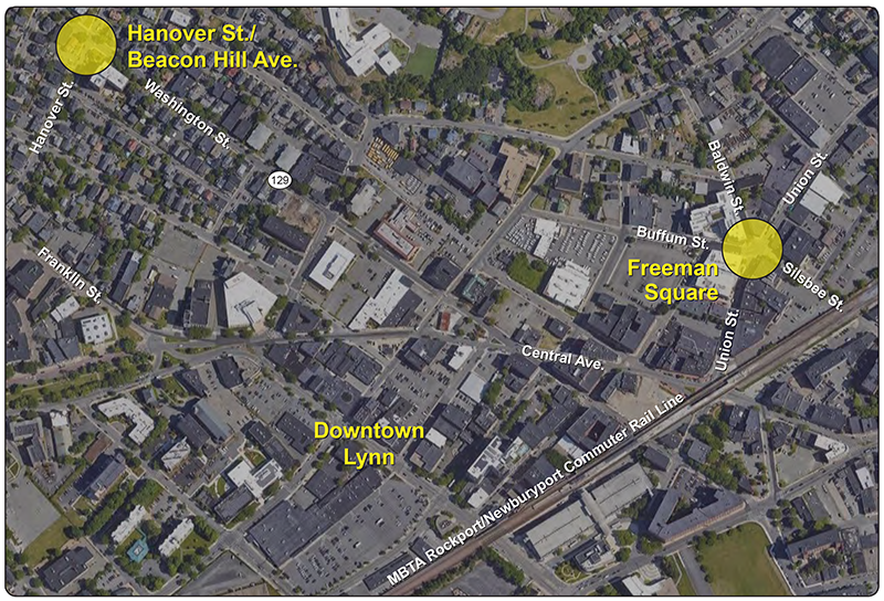
The intersections studied are both located in the city of Lynn. The first, the intersection of Route 129 (Washington Street) and Hanover Street and Beacon Hill Avenue, is located northwest of downtown Lynn. The second is Freeman Square—the intersection of Union, Buffum, Baldwin, and Silsbee Streets—which is located east of the downtown area of Lynn within the city center. Figure 1 shows each location within the city of Lynn. There are numerous safety issues at each intersection.
Figure 1
Study Areas

Route 129 (Washington Street) is an important connector in the city of Lynn. It connects the center of the city to Route 107 (Western Avenue). It runs mostly in a northwest-southeast direction and is a two-lane roadway. Most of the land use around the route is residential, but there is primarily commercial development at the northern and southern ends of the route—near Western Avenue and downtown, respectively. The study intersection is in the middle of the residential section of Washington Street. Hanover Street and Beacon Hill Avenue are residential connectors that run primarily northeast-southwest. These roads do not carry as high a volume of traffic as Washington Street.
The Louis Barret Residences—an apartment complex for those 55 years of age or older—is located on the corner of Washington Street and Hanover Street. In addition to other single- and multi-family housing surrounding the intersection, there is also a barber shop (Menor da Barber Studio) and a funeral home (Goodrich Funeral Home) within the study area. The intersection is near Cobbet Elementary School and the Boys and Girls Club of Lynn. It is widely used by students walking to and from school and older populations who live in the Louis Barret apartments.
Union Street is the primary route that travels through Freeman Square. It is a two-lane mostly north-south roadway that connects the center of the city to residential areas east of downtown Lynn. The other streets that meet at the intersection of Freeman Square are Buffum Street, Baldwin Street, and Silsbee Street. Buffum is a two-way east-west connector between Freeman Square and Liberty Street. Baldwin and Silsbee Streets are one-way routes. Both carry traffic out of the intersection—Baldwin Street northwest-bound and Silsbee Street eastbound.
Most of the land use near the intersection is commercial or mixed-use. There are numerous businesses and restaurants around Freeman Square, but one of the anchors of the neighborhood is the Lynn Community Health Center (LCHC). The LCHC provides primary care services to more than 40 percent of Lynn residents.1 Because the LCHC is located in Freeman Square, many people traveling through the intersection are traveling to the health center, whether they are patients or employees. Other notable destinations near Freeman Square include the Greater Lynn Senior Services Center, Family Dollar, and a variety of restaurants and stores.
MPO staff coordinated with the City of Lynn and the LCHC to establish dates for in-person public engagement opportunities. After discussions with stakeholders, it was determined that a short survey would be prepared for each study intersection and distributed via in-person methods. Staff provided incentives ($5 Dunkin Donuts gift cards) to recognize the participation of people who engaged with staff to discuss the intersections and answer survey questions. The survey questions for each intersection can be found in Appendix A.
The survey prepared for the intersection of Route 129 (Washington Street) at Hanover Street and Beacon Hill Avenue included five questions regarding user safety. The residents at the Louis Barrett Residences were one of the major groups of stakeholders who were intended to be reached by this survey. MPO staff made multiple attempts to contact the management of the Louis Barrett Residences in order to set up a time to distribute surveys to residents; but unfortunately, staff were unable to make progress on that front. In lieu of setting up a formal survey distribution, staff visited the study intersection on Tuesday, August 1, and Tuesday, August 8, 2023, to chat with residents and other people in the neighborhood. Staff spoke to a number of people each day, including residents of the Louis Barrett Residences and others in the neighborhood, and recorded their responses to the survey.
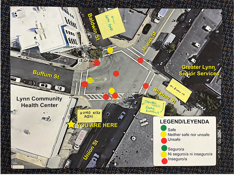
A similar survey was prepared for the Freeman Square intersection, but staff were better able to engage with the public via four days of tabling in the study area. After coordinating with the City of Lynn and LCHC, MPO staff were able to set up outside of the LCHC between 3:00 PM and 5:00 PM on Monday, July 31, Tuesday, August 1, Monday, August 7, and Tuesday, August 8. At each of these events, a posterboard with an aerial image of the intersection was available for people to note areas of the intersection where they felt safe, unsafe, and neither safe nor unsafe. Figure 2 is an image of the posterboard with stickers and notes about safety issues and improvements placed by members of the public. (The photo was taken on Tuesday, August 8.) In addition to the posterboard, staff brought tablets with the survey questions and were able to fill them out based on how participants responded.
Figure 2
Freeman Square Engagement Posterboard
An interpreter provided by the City of Lynn was in attendance on Monday, July 31, and Monday, August 7, to assist in better engagement with the Spanish-speaking participants and Spanish-speaking MPO staff were also present on Monday, July 31, Tuesday, August 1, and Tuesday, August 8.
For both intersections, staff engaged roughly the same number of English and Spanish speakers. Staff collected demographic information from survey respondents, and the majority of respondents identified as being Hispanic or Latino/a and having a household income that MPO staff classify as low income (less than 200 percent of the federal poverty line). Nearly half of respondents identified as having a disability.
In addition to reaching out to management at the Louis Barrett Residences at Washington Street and Hanover Street, and other businesses in the area, staff visited the intersection and canvassed residents of the Louis Barrett residences and other people passing through the area to discuss the study and collect survey responses. Survey responses can be found in Appendix A. Many respondents reported witnessing car collisions in the intersection and knowing people who had been involved in accidents. One respondent reported being hit in the intersection while crossing on foot. Most respondents reported feeling very unsafe in the intersection and raised several specific safety concerns, especially regarding vehicle speed and driver behavior.
When asked about possible safety improvements for the intersection, respondents suggested better signage and signalization for the pedestrian crossings, including full signal lights, a crossing guard (especially during the school year), and signage to indicate the presence of children, older adults, and/or people with disabilities in the area. Respondents also suggested moving the light and crossing on Washington Street by the Louis Barrett Residences entrance to the Hanover Street intersection. Below are summaries of additional comments that staff recorded:
Staff collected 40 survey responses while tabling at Freeman Square; several other people also participated in the interactive intersection safety mapping activity (Figure 2). Twenty-one respondents completed the survey in English, and 17 respondents completed the survey in Spanish. Staff also collected one response in Haitian Creole and one in Arabic.
The majority of respondents to the Freeman Square intersection (30) indicated that they usually crossed the intersection and traveled through the area on foot or using a mobility device, while many respondents (13) also indicated that they drove, and a small number took the bus or used a rideshare/ride-hailing service. Visiting LCHC was the most commonly cited reason for traveling through the area (25), followed by visiting stores or restaurants (13), then working (6) and living nearby (6). A few respondents also indicated that they traveled through the area for recreation or fitness purposes and to access other social services.
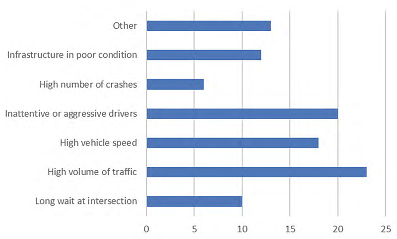
The overwhelming majority of respondents indicated that they feel unsafe crossing or traveling through Freeman Square. Figure 3 illustrates the frequency of specific problems respondents cited. Among additional comments respondents provided under the “other” category (shown in Figure 3), several responses expanded on infrastructure condition, citing the excessive length of the crosswalks, poor visibility of crosswalk markings, and poor lighting in the square at night. Several other responses expanded on driver behavior, sharing stories of “near-miss” collisions with drivers who were distracted (using phones) and drivers who pulled out into the intersection quickly and aggressively, often cutting off other pedestrians and vehicles and blocking the crosswalks. Responses also indicated some general confusion about (or disregard of) right-of-way in the intersection, parking regulations near the intersection, and direction of traffic flow on the streets leading into and out of the intersection.
Figure 3
Respondents’ Selections of Specific Problems in Freeman Square
When asked about possible safety improvements to Freeman Square, the majority of respondents supported improvements to pedestrian accommodations, such as crosswalks and sidewalks. Respondents also supported general safety improvements for all road users and interventions to reduce traffic congestion in the area. Below are summaries of specific responses about intersection improvements:
Based on staff’s field observations, discussions with City officials, public engagement results, stakeholder interviews, and analyses of crash data and existing operations, major issues at each intersection were identified as the following:
Crash data analysis is essential to identify safety and operational problems at an
intersection. Analyzing data on the frequency of crashes, types and patterns of
collisions, and the circumstances under which crashes occur, such as the time of
day and roadway surface conditions, also helps to develop improvement
strategies.
MPO staff used the most recent six-year crash reports (January 2016–December 2021) for this study. Data was obtained using MassDOT’s IMPACT Crash Portal. Typically, five years of crash data is used, but an additional year of crash data was collected to account for the COVID-19 pandemic effects on vehicular travel in 2020. It should be noted that these are just reported crashes. Feedback from the community indicates that there likely could be unreported crashes at both intersections.
There were 50 crashes in the six-year period at the intersection of Washington and Hanover Streets. The majority of crashes in the area occurred directly at the intersection, but there were a few crashes along Washington Street approaching the intersection. This intersection fell within the top-five percent of crash clusters statewide. The predominant crash type was the angle crash (37 crashes). The others included six rear-end crashes, four crashes involving a single vehicle only, two in which vehicles sideswiped each other while traveling in the same direction, and one sideswipe of vehicles traveling in opposite directions.
Table 1 summarizes the 50 crashes in terms of severity, collision type, pedestrian or bicycle involvement, time of the day, and weather and pavement conditions. Eighteen crashes (36 percent) caused personal injuries with no fatalities. Nearly half (48 percent) of all crashes occurred during peak periods (6:00 AM–10:00 AM and 2:00 PM–6:00 PM). More than a third (38 percent) of the collisions occurred during dark conditions.
Table 1
Crash Summary at the Intersection of Washington Street, Hanover Street, and Beacon Hill Avenue
Statistics Period |
2016 |
2017 |
2018 |
2019 |
2020 |
2021 |
6-Year Total |
Annual Average |
Total number of crashes |
16 |
4 |
6 |
6 |
8 |
10 |
50 |
8.3 |
Severity |
|
|
|
|
|
|
|
|
Property damage only |
9 |
2 |
3 |
3 |
5 |
9 |
31 |
5.2 |
Non-fatal injury |
7 |
2 |
3 |
3 |
2 |
1 |
18 |
3.0 |
Fatality |
0 |
0 |
0 |
0 |
0 |
0 |
0 |
0.0 |
Not reported/unknown |
0 |
0 |
0 |
0 |
1 |
0 |
1 |
0.2 |
Collision type |
|
|
|
|
|
|
|
|
Single vehicle |
0 |
2 |
2 |
0 |
0 |
0 |
4 |
0.7 |
Rear-end |
2 |
0 |
1 |
0 |
1 |
2 |
6 |
1.0 |
Angle |
13 |
2 |
3 |
6 |
6 |
7 |
37 |
6.2 |
Sideswipe, same direction |
0 |
0 |
0 |
0 |
1 |
1 |
2 |
0.3 |
Sideswipe, opposite direction |
1 |
0 |
0 |
0 |
0 |
0 |
1 |
0.2 |
Head-on |
0 |
0 |
0 |
0 |
0 |
0 |
0 |
0.0 |
Rear-to-rear |
0 |
0 |
0 |
0 |
0 |
0 |
0 |
0.0 |
Not reported/unknown |
0 |
0 |
0 |
0 |
0 |
0 |
0 |
0.0 |
Involved pedestrian(s) |
0 |
1 |
2 |
0 |
0 |
0 |
3 |
0.5 |
Involved cyclist(s) |
1 |
0 |
0 |
0 |
0 |
0 |
1 |
0.2 |
Occurred during weekday peak periods* |
7 |
3 |
2 |
3 |
4 |
5 |
24 |
4.0 |
Wet or icy pavement conditions |
3 |
0 |
2 |
2 |
1 |
2 |
10 |
1.7 |
Dark conditions (lit or unlit) |
6 |
0 |
3 |
3 |
3 |
4 |
19 |
3.2 |
* Peak periods are defined as 6:00 AM–10:00 AM and 2:00 PM–6:00 PM
Source: Central Transportation Planning Staff.
There were 70 crashes in the six-year period in the area of Freeman Square. Most crashes in the area occurred at the intersection and along Union Street.
The predominant crash types were sideswipes of vehicles traveling in the same direction (24 crashes), and rear-end (15), angle (14), and single-vehicle crashes (11). There were also three crashes not reported or of unknown type, two sideswipes of vehicles traveling in opposite directions, and one head-on crash. Table 2 summarizes the 70 crashes in terms of severity, collision type, pedestrian or bicycle involvement, time of the day, and weather and pavement conditions.
Eleven crashes (17 percent) caused personal injuries with no fatalities. There was one fatality in March of 2018. It involved a pedestrian in the crosswalk on Silsbee Street and a vehicle turning from Union Street. Twenty-six crashes occurred during peak periods (6:00 AM–10:00 AM and 2:00 PM–6:00 PM). Less than a third (30 percent) of the collisions occurred during dark conditions.
Table 2
Crash Summary at Freeman Square
Statistics Period |
2016 |
2017 |
2018 |
2019 |
2020 |
2021 |
6-Year Total |
Annual Average |
Total number of crashes |
15 |
24 |
6 |
5 |
8 |
12 |
70 |
11.7 |
Severity |
|
|
|
|
|
|
|
|
Property damage only |
13 |
20 |
4 |
2 |
7 |
10 |
56 |
9.3 |
Non-fatal injury |
1 |
4 |
1 |
3 |
1 |
1 |
11 |
1.8 |
Fatality |
0 |
0 |
1 |
0 |
0 |
0 |
1 |
0.2 |
Not reported/unknown |
1 |
0 |
0 |
0 |
0 |
1 |
2 |
0.3 |
Collision type |
|
|
|
|
|
|
|
|
Single vehicle |
0 |
5 |
2 |
1 |
3 |
0 |
11 |
1.8 |
Rear-end |
2 |
5 |
2 |
3 |
2 |
1 |
15 |
2.5 |
Angle |
3 |
4 |
1 |
0 |
3 |
3 |
14 |
2.3 |
Sideswipe, same direction |
8 |
9 |
0 |
1 |
0 |
6 |
24 |
4.0 |
Sideswipe, opposite direction |
0 |
1 |
0 |
0 |
0 |
1 |
2 |
0.3 |
Head-on |
1 |
0 |
0 |
0 |
0 |
0 |
1 |
0.2 |
Rear-to-rear |
0 |
0 |
0 |
0 |
0 |
0 |
0 |
0.0 |
Not reported/unknown |
1 |
0 |
1 |
0 |
0 |
1 |
3 |
0.5 |
Involved pedestrian(s) |
2 |
5 |
2 |
1 |
1 |
1 |
12 |
2.0 |
Involved cyclist(s) |
0 |
0 |
0 |
0 |
0 |
0 |
0 |
0.0 |
Occurred during weekday peak periods* |
4 |
14 |
0 |
1 |
3 |
4 |
26 |
4.3 |
Wet or icy pavement conditions |
1 |
7 |
2 |
1 |
1 |
1 |
13 |
2.2 |
Dark conditions (lit or unlit) |
4 |
7 |
2 |
3 |
1 |
2 |
19 |
3.2 |
* Peak periods are defined as 6:00 AM–10:00 AM and 2:00 PM–6:00 PM
Source: Central Transportation Planning Staff.
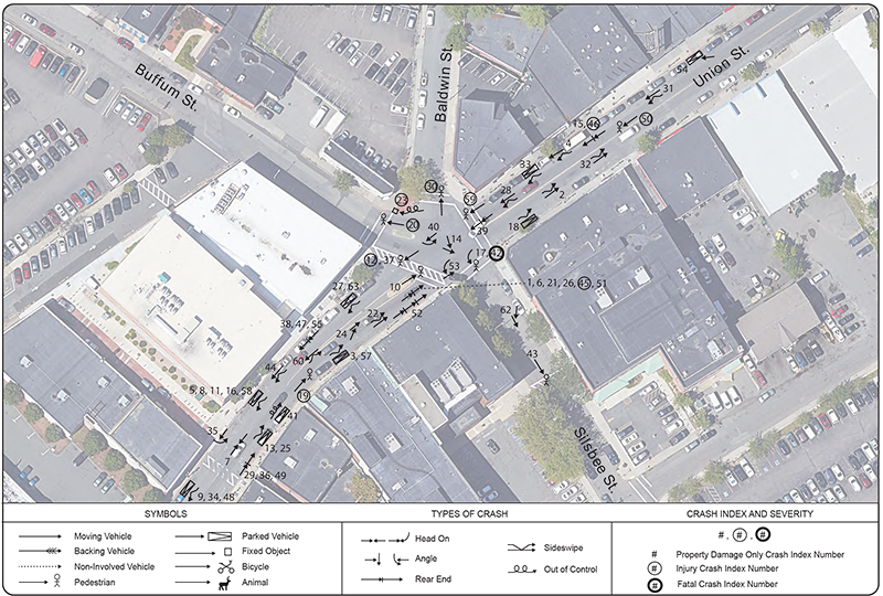
Based on the police reports, staff constructed collision diagrams (Figures 4 and 5) that show the locations and patterns of all the crashes at each intersection. The information about each crash, including date, time, severity, collision type, most harmful event, weather conditions, and driver contributing code are summarized in Appendix B.
Figure 4
Collision Diagram: Washington Street at Hanover Street and Beacon Hill Avenue in Lynn, Police Crash Reports 2016–21
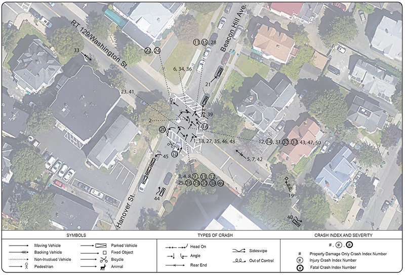
Figure 5
Collision Diagram: Freeman Square, Lynn Police Crash Reports 2016–21
To examine the existing conditions, MPO staff requested MassDOT’s assistance in collecting Automatic Traffic Recorder (ATR) counts on the approaching roadways and intersection turning movement counts (TMCs) for this study. The ATR counts were performed during the week of April 10–16, 2023. The TMCs were collected Thursday, April 13, and Saturday, April 15, 2023. Further detail of the ATR counts can be found in Appendix C.
Additional data was collected near the intersection of Washington Street and Hanover Street. Due to comments from City staff about speeding concerns along Washington Street, speed data was collected at a location northwest of the intersection. Pedestrian count data was also collected at the mid-block crossing on Washington Street, located southeast of the intersection, directly in front of the Louis Barrett apartments (included in Appendix C).
Based on the data, staff estimated the average weekday traffic volumes in roadway sections near the intersection as follows:
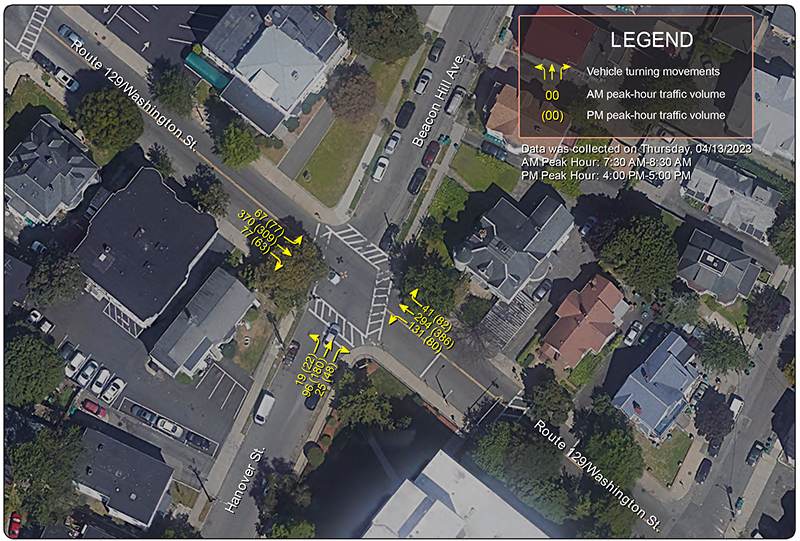
MassDOT collected turning movement counts at the study intersection on Thursday, April 13, 2023, during the morning peak period (6:00 AM–10:00 AM) and the evening peak period (2:00 PM–6:00 PM), and on Saturday, April 15, 2023, during the midday peak period (10:00 AM–2:00 PM). Figure 6 summarizes the 2023 AM and PM peak-hour traffic turning volumes by approach at the intersection.
Figure 6
Weekday Peak-Hour Turning Movement Counts
Washington Street at Hanover Street/Beacon Hill Avenue in Lynn
Speeding was noted as an issue along Washington Street. City staff have commented that many drivers use the street as a cut-through between downtown Lynn and Western Avenue. Residents of the Louis Barrett apartments also commented that they notice vehicles speeding and have witnessed near-miss crashes due to speeding.
The speed limit along Washington Street in the study area is 25 miles per hour. Speed data was collected by MassDOT between April 10 and April 18, 2023. The data show that the estimated 85th percentile speed of southeast-bound vehicles ranges between 29.2 miles per hour and 32.1 miles per hour. In the northwest-bound direction, the speed was 28.6 miles per hour and 33.7 miles per hour for each of the days speeds were collected. Further detail of the speed collection can be found in Appendix C.
Based on the 2023 AM and PM peak-hour turning movements, staff conducted the intersection capacity analysis for the intersection of Washington Street at Hanover Street by using the Synchro traffic analysis and simulation program.3
Staff conducted traffic operations analyses consistent with the Highway Capacity Manual (HCM) methodologies (included in Appendix D). HCM methodology demonstrates driving conditions at signalized and unsignalized intersections in terms of level-of-service (LOS) ratings from A through F. LOS A represents the best operating conditions (little to no delay), while LOS F represents the worst operating conditions (very long delay). LOS E represents operating conditions at capacity (limit of acceptable delay). The Synchro capacity analysis can be found in Appendix E. Table 3 summarizes the delays, LOS, and queue lengths for the existing conditions. Traffic on Hanover Street experiences LOS E during the morning peak hours and LOS F during the evening peak hours. Traffic on Washington Street operates at LOS A during the same hours.
Investigating the need for a traffic control signal at an unsignalized intersection involves analyzing factors related to the existing traffic operations and safety conditions at the intersection, as well as the potential to improve these conditions. Such an investigation is called a traffic signal warrant analysis. The Manual on Uniform Traffic and Control Devices (MUTCD) lists nine traffic signal warrants that justify installing a traffic signal. Using the methodology outlined in the 2009 edition of the MUTCD, staff performed detailed traffic signal warrant analyses to determine whether the installation of a traffic control signal at the intersection of Washington Street and Hanover Street/Beacon Hill Avenue is justified and if signalizing the intersection would improve safety and traffic operations. Existing conditions at the intersection of Washington Street and Hanover Street/Beacon Hill Avenue satisfy two of the warrants: Warrant 2, Four-Hour Vehicular Volumes and Warrant 3, Peak Hour Vehicular Volume. Detailed traffic signal warrant analysis worksheets are included in Appendix D.
Table 3
Intersection Capacity Analysis
Washington Street at Hanover Street/Beacon Hill Avenue
Approach |
AM |
AM |
AM |
PM |
PM |
PM |
Existing Conditions |
||||||
Hanover St. NB |
48.1 |
E |
105 |
74.4 |
F |
225 |
Washington St. EB |
1.7 |
A |
7 |
2.3 |
A |
10 |
Washington St. WB |
3.7 |
A |
10 |
2.1 |
A |
10 |
All approaches |
7.6 |
A |
|
16 |
C |
|
2030 No Build |
||||||
Hanover St. NB |
48.9 |
E |
112.5 |
72.5 |
F |
230 |
Washington St. EB |
2 |
A |
7 |
2.4 |
A |
8 |
Washington St. WB |
4 |
A |
13 |
2.1 |
A |
9 |
All approaches |
7.7 |
A |
|
15.6 |
C |
|
2030 Alternative One |
||||||
Hanover St. NB |
12.4 |
B |
30 |
18.1 |
C |
82.5 |
Washington St. EB |
31.6 |
D |
253 |
35.8 |
E |
243 |
Washington St. WB |
26 |
D |
200 |
71.1 |
F |
427.5 |
All approaches |
26.9 |
D |
|
47.8 |
E |
|
2030 Alternative Two |
||||||
Hanover St. NB |
19.9 |
B |
106 |
27.5 |
C |
250 |
Washington St. EB |
13.7 |
B |
228 |
15.2 |
B |
306 |
Washington St. WB |
17.1 |
B |
238 |
19.2 |
B |
452 |
All approaches |
15.9 |
B |
|
10.4 |
B |
|
EB = eastbound. LOS = level of service. NB = northbound. SB = southbound. WB = westbound.
Source: Central Transportation Planning Staff.
Based on the data, staff estimated the average weekday traffic volumes in roadway sections near the intersection as follows:
MassDOT collected turning movement counts at the study intersection on Thursday, April 13, 2023, during the morning peak period (6:00 AM–10:00 AM) and the evening peak period (2:00 PM–6:00 PM), and on Saturday, April 15, 2023, during the midday peak period (10:00 AM–2:00 PM). Figure 7 summarizes the 2023 AM and PM peak-hour traffic turning volumes by approach at the intersection (included in Appendix C).
Based on the 2023 AM and PM peak-hour turning movements, staff conducted the intersection capacity analysis for the Freeman Square intersection by using the Synchro traffic analysis and simulation program. During the morning peak hours, traffic at all approaches to the intersection experiences LOS B. During the evening peak hours, traffic at all approaches experiences LOS D. The Synchro capacity analysis can be found in Appendix F. Table 4 summarizes the delays, LOS, and queue lengths. Traffic on Buffum Street and Union Street operate at LOS B during the morning peak hours and LOS C or D during the evening peak hours.
Figure 7
Weekday Peak-Hour Turning Movement Counts
Freeman Square in Lynn
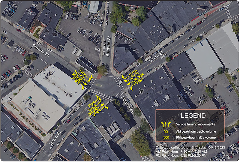
Table 4
Intersection Capacity Analysis
Freeman Square
Approach |
AM |
AM |
AM |
PM |
PM |
PM |
Existing Conditions |
||||||
Union St. NB |
12.2 |
B |
60 |
26.6 |
D |
182.5 |
Union St. SB |
14 |
B |
7 |
25.5 |
D |
175 |
Buffum St. EB |
12 |
B |
88 |
19.3 |
C |
100 |
All approaches |
12.8 |
B |
|
24.3 |
C |
|
2030 No Build |
||||||
Union St. NB |
12.3 |
B |
57.5 |
35.5 |
E |
242.5 |
Union St. SB |
17.9 |
C |
132.5 |
24.9 |
C |
162.5 |
Buffum St. EB |
12.2 |
B |
42.5 |
22 |
C |
122.5 |
All approaches |
14.9 |
B |
|
28.3 |
D |
|
2030 Alternative One |
||||||
Union St. NB |
12.3 |
B |
57.5 |
35.5 |
E |
242.5 |
Union St. SB |
17.9 |
C |
132.5 |
24.9 |
C |
165 |
Buffum St. EB |
12.2 |
B |
42.5 |
22 |
C |
122.5 |
All approaches |
14.9 |
B |
|
28.3 |
D |
|
2030 Alternative Two |
||||||
Union St. NB |
6.8 |
A |
25 |
13.5 |
B |
100 |
Union St. SB |
6.3 |
A |
50 |
6.1 |
A |
50 |
Buffum St. EB |
6.9 |
A |
25 |
8.2 |
A |
50 |
All approaches |
6.6 |
A |
|
9.6 |
A |
|
EB = eastbound. LOS = level of service. NB = northbound. SB = southbound. WB = westbound.
Source: Central Transportation Planning Staff.
Based on the above analyses, MPO staff developed a series of short- and long-term improvements to address safety and operational problems at the intersections. The proposed short-term improvements generally can be implemented within a few years at a low cost. The proposed long-term improvements cover larger areas, require intensive planning and design, and require more significant funding. These improvements are analyzed in the next section.
The proposed short-term improvements are summarized below and shown in Figure 8.
The proposed short-term improvements would increase safety for people using the intersection (walking, biking, driving, or using assistive mobility devices). These improvements are estimated to cost between $20,000 and $30,000.
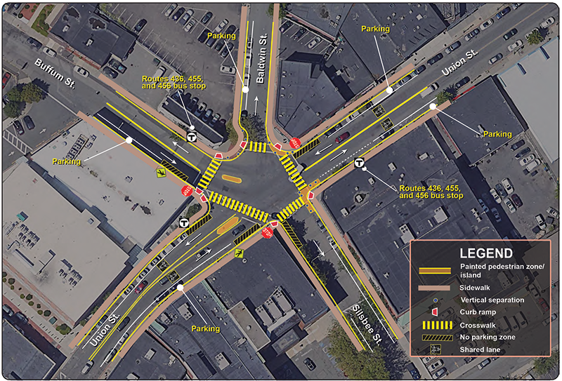
The proposed short-term improvements are summarized below and shown in Figure 9.
The short-term improvements would increase safety for people using the intersection (walking, biking, or using assistive mobility devices). The improvements are estimated to cost between $30,000 and $40,000.
According to the Crash Modification Factors (CMF) Clearinghouse database, curb extensions and parking prohibition near intersections reduce pedestrian crossing delays, increase driver yield rates, reduce turn speeds, and improve driver visibility of people using crosswalks at intersections. Studies have shown that implementing improvements that increase visibility of pedestrians could reduce vehicle-pedestrian crashes by as much as 40 percent.5
Figure 8
Short-Term Improvements
Washington Street at Hanover Street/Beacon Hill Avenue in Lynn
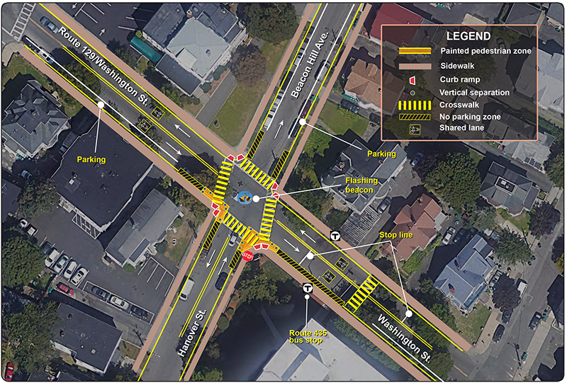
Figure 9
Short-term Improvements
Freeman Square in Lynn
The proposed long-term improvements would require additional planning and design and more significant funding. Staff identified two alternatives for each intersection, based on the goals of maximizing safety and operational benefits for all transportation modes and minimizing construction impacts.
Staff also analyzed traffic operations for the alternatives and the base case (no-build scenario) under projected 2030 traffic conditions. For comparison purposes, the analysis included future-year no-build scenarios for each intersection that contain no geometric modifications and no changes to intersection controls (included in Tables 3 and 4). Future-year no build Synchro analyses for each intersection can be found in Appendix G.
Key elements of the two alternatives for each intersection are summarized below. Route 129 at Hanover Street and Beacon Hill Avenue future-year Synchro analyses for Alternatives One and Two can be found in Appendix H. Freeman Square future-year Synchro analyses for Alternatives One and Two can be found in Appendix I.
Alternative One would change the intersection control to an all-way stop. It also includes geometric modifications to the right-of-way. Figure 10 illustrates these changes. Key elements of the alternative include the following:
The improvements in Alternative One would increase safety for people using the intersection. The improvements are estimated to cost between $50,000 and $60,000. According to the CMF Clearinghouse database, converting a two-way stop-controlled intersection into an all-way stop-controlled intersection could reduce crashes by as much as 80 percent.
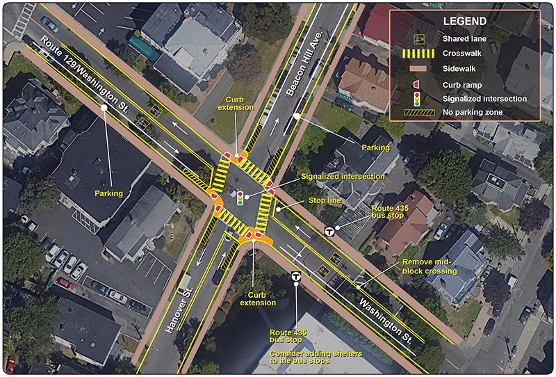
Alternative Two would change the intersection control to a traffic signal that controls the flow of vehicles and provides sufficient time for safe and efficient pedestrian crossings. Existing conditions at the intersection of Washington Street and Hanover Street/Beacon Hill Avenue satisfy two of the warrants. Geometric modifications to the right-of-way are the same as in Alternative One. Figure 11 illustrates the changes listed below. Key elements of the alternative include the following:
According to the CMF database, the improvements in Alternative Two would increase safety for people using the intersection by as much as 44 percent. The improvements are estimated to cost between $1.2 million and $1.5 million. The results presented in Table 3 indicate that Alternative Two produces less delay during the morning and evening peak hours than Alternative One.
Figure 10
Alternative One: Pedestrian Safety Enhancements
Washington Street at Hanover Street/Beacon Hill Avenue in Lynn
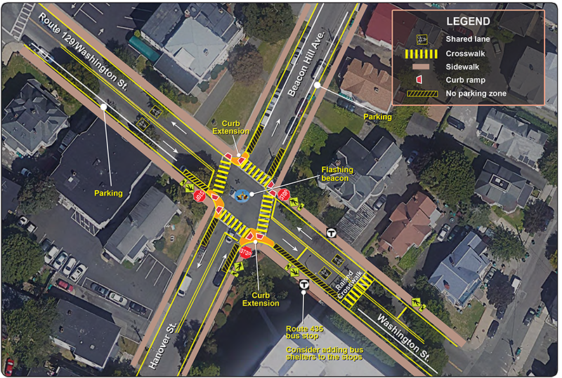
Figure 11
Alternative Two: Signalized Intersection
Washington Street at Hanover Street/Beacon Hill Avenue in Lynn
Alternative One for the Freeman Square intersection would keep the intersection control the same but add geometric modifications to the right-of-way, in addition to other installations, to promote safer travel through the intersection. Figure 12 displays the geometric changes listed below. Key elements of the alternative include the following:
The improvements in Alternative One would increase safety for people using the intersection and enhance bus stop amenities. The improvements are estimated to cost between $70,000 and $80,000. The CMF database indicates that the pedestrian visibility enhancements could reduce crashes by as much as 40 percent.
Silsbee Street is currently a one-way street that carries traffic eastbound out of the intersection. Its pavement width from curb to curb is about 32 feet and there is on-street parking on both sides. Converting it into a two-way, two-lane operation will improve connections to the commuter rail station.
Analysis indicates that two-way, two-lane traffic may be feasible if parking is allowed on only one side of the street. This would allow space for two ten-foot travel lanes, pavement striping, and an eight-foot on-street parking area on one side. However, additional evaluation on how much traffic this conversion would divert through the intersection and its impact on traffic safety and operations is necessary. This evaluation is beyond the scope of this study.
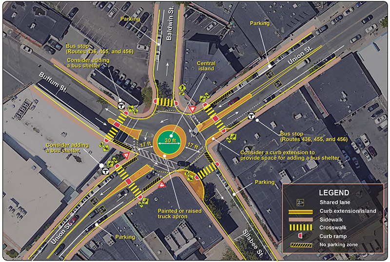
Alternative Two for the Freeman Square intersection would modify the intersection to a small roundabout, changing the geometry and control of the existing intersection. A 30-foot central island with painted or raised truck apron and a 17-foot circulating lane would fit the existing space. Figure 13 illustrates the changes described below. Key elements of the alternative include the following:
The improvements in Alternative Two would increase safety for people using the intersection and enhance bus stop amenities. Roundabouts have proved effective in reducing traffic speeds, crash frequency and severity, traffic delays, and long-term operational costs. In addition, they are environmentally friendly and more aesthetically pleasing with landscaping improvements. This small roundabout retrofit is estimated to cost approximately $500,000. The CMF database indicates that retrofitting an intersection with a roundabout could reduce crashes by as much as 44 percent.
The results presented in Table 4 show that Alternatives One and Two produce acceptable delays and LOS during the morning and evening peak hours. However, Alternative Two produces less delay during the morning and evening peak hours than Alternative One. Alternative Two would reduce travel speeds and crash severity and provide a welcoming environment at Freeman Square.
Staff submitted this memorandum to stakeholders for comments on the short- and long-term alternatives. Comments received from stakeholders are included in Appendix J.Figure 12
Alternative One
Freeman Square in Lynn
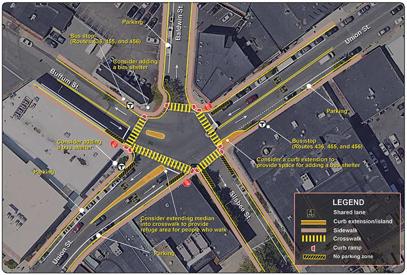
Figure 13
Alternative Two: Roundabout/Traffic Circle
Freeman Square in Lynn
This study performed a series of safety and operations analyses, identified issues and concerns, and proposed short- and long-term improvements at the intersections. The proposed short-term improvements would enhance safety and operations for the intersections under the existing conditions. The proposed long-term improvements—such as signalizing or retrofitting an intersection with a roundabout; adding ADA-compliant curb ramps; adding necessary curb extensions; installing bus shelters; improving streetlights; and improving infrastructure for people who walk, bike, or use assistive mobility devices—would significantly address the safety and operational problems at the intersections.
At this preliminary planning stage, staff recommend that all proposed alternatives should be included and further investigated at the functional design stage. With a relatively high benefit/cost ratio, they should be implemented as resources are available from highway maintenance or local Chapter 90 funding or through Shared Streets and Spaces grants.
The City of Lynn has jurisdiction of the intersections and roadways in the study area and is responsible for renovation of the intersections to improve safety, mobility, connectivity, and operations. This study gives the City an opportunity to address the needs of the intersection and plan for design and engineering. The next steps would be to select the preferred alternative that is sensitive to the goals and needs of stakeholders and advance the project through the planning process. These steps will depend upon cooperation between MassDOT, the City, and the MPO to begin the project notification and review process and complete the project initiation form. After completing the initial steps, City and MassDOT staff can start preliminary design and engineering to place the project in the Boston Region MPO’s Transportation Improvement Program.
2 Beacon Hill Avenue is a one-way street, so there is no split between directions of travel.
3 Staff used Synchro Version 10.3, developed and distributed by Trafficware Ltd. It can perform capacity analysis and traffic simulation (when combined with SimTraffic) for an individual intersection or a series of intersections in a roadway network.
4 Baldwin and Silsbee Streets are one-way, so there are no splits between directions of travel.
5 Crash Modification Factors (CMF) Clearinghouse, United States Department of Transportation, Federal Highway Administration, June 26, 2023, CMF Clearinghouse
6 National Association of City Transportation Officials guidance on mid-block crossings: https://nacto.org/publication/urban-street-design-guide/intersection-design-elements/crosswalks-and-crossings/midblock-crosswalks/
Appendices
Appendix A: Survey Questions and Responses
Appendix B: Collision Diagram Lookup Tables
Appendix C: Traffic and Speed Data
Appendix D: Highway Capacity Manual Methodology
Appendix E: Washington Street at Hanover Street, Existing Conditions
Appendix F: Freeman Square, Existing Conditions
Appendix G: 2030 No Build Analysis
Appendix H: Washington Street at Hanover Street, 2030 Alternatives One and Two
Appendix I: Freeman Square, 2030 Alternatives One and Two
The Boston Region Metropolitan Planning Organization (MPO) operates its programs, services, and activities in compliance with federal nondiscrimination laws including Title VI of the Civil Rights Act of 1964 (Title VI), the Civil Rights Restoration Act of 1987, and related statutes and regulations. Title VI prohibits discrimination in federally assisted programs and requires that no person in the United States of America shall, on the grounds of race, color, or national origin (including limited English proficiency), be excluded from participation in, denied the benefits of, or be otherwise subjected to discrimination under any program or activity that receives federal assistance. Related federal nondiscrimination laws administered by the Federal Highway Administration, Federal Transit Administration, or both, prohibit discrimination on the basis of age, sex, and disability. The Boston Region MPO considers these protected populations in its Title VI Programs, consistent with federal interpretation and administration. In addition, the Boston Region MPO provides meaningful access to its programs, services, and activities to individuals with limited English proficiency, in compliance with U.S. Department of Transportation policy and guidance on federal Executive Order 13166. The Boston Region MPO also complies with the Massachusetts Public Accommodation Law, M.G.L. c 272 sections 92a, 98, 98a, which prohibits making any distinction, discrimination, or restriction in admission to, or treatment in a place of public accommodation based on race, color, religious creed, national origin, sex, sexual orientation, disability, or ancestry. Likewise, the Boston Region MPO complies with the Governor's Executive Order 526, section 4, which requires that all programs, activities, and services provided, performed, licensed, chartered, funded, regulated, or contracted for by the state shall be conducted without unlawful discrimination based on race, color, age, gender, ethnicity, sexual orientation, gender identity or expression, religion, creed, ancestry, national origin, disability, veteran's status (including Vietnam-era veterans), or background. A complaint form and additional information can be obtained by contacting the MPO or at http://www.bostonmpo.org/mpo_non_discrimination. To request this information in a different language or in an accessible format, please contact Title VI Specialist By Telephone: For people with hearing or speaking difficulties, connect through the state MassRelay service:
For more information, including numbers for Spanish speakers, visit https://www.mass.gov/massrelay.
|