Appendix A—Scenario Planning Process
1 Introduction
As described in Chapter 2, the MPO used scenario planning to help shed light on the relative merits of two different approaches to congestion: Should the MPO continue to use a congestion-reduction approach by investing in major arterials and express highways? Or, should the MPO adopt a capacity-management approach by investing in smaller-scale, but more diverse and geographically dispersed, operations and management (O&M)-type projects? To answer these questions, staff compared three scenarios to a base-case scenario using both the regional travel demand model set and off-model analyses. Included in this appendix is a summary of the scenario-planning process that was undertaken as part of this LRTP development.
Results of the analysis helped the MPO finalize its goals and objectives and select a set of programs and projects to analyze to determine which ones to include in the LRTP. The MPO adopted the O&M approach to programming in the LRTP. This new policy direction signaled a pivotal change in the MPO’s approach to programming transportation investments.
POLICY QUESTION FOR SCENARIO PLANNING
For this Long-Range Transportation Plan (LRTP), Charting Progress to 2040, the Boston Region MPO examined how allocating available dollars to various strategies would best address the region’s transportation needs, while advancing the MPO’s vision, goals and objectives. Themes of the MPO’s goals are:
1. Safety
2. System Preservation
3. Capacity Management/Mobility
4. Clean Air/Clean Communities
5. Transportation Equity
6. Economic Vitality
To support the plan’s development, MPO staff conducted scenario planning to help the MPO and the public weigh the benefits and tradeoffs of different investment strategies.
The MPO considered two different approaches to addressing mobility needs during the next 25 years, focusing on a specific policy question related to a proposed objective within its Capacity Management and Mobility goal:
“Should the MPO give priority in a congestion reduction program to major arterials and express highways throughout the region which serve transit and/or existing population and places of employment?”
This policy shaped the MPO’s approach to future transportation investments. One approach was to program primarily high-cost roadway projects, while another option concentrated on lower-cost, often multimodal types of investments. The purpose of this scenario planning was to help clarify the degree to which each of these approaches would help the MPO progress toward its goal of improving mobility, along with its other stated goals.
To shed light on the policy question cited above, the MPO established one base-case scenario and three alternatives. Each scenario reflected a different hypothetical investment approach that the MPO could follow over the next 25 years. These scenarios have several elements in common:
• All four scenarios look out to the LRTP horizon year of 2040.
• The socioeconomic (population, household, and employment) data is the same for all scenarios.
By 2040, the population in the MPO’s model region (164 communities) is expected to rise by 12.9 percent
to approximately 4,854,000 people. Employment in the same region is expected to rise by 7.7 percent to
approximately 2,579,000 jobs.
• All scenarios are financially constrained to the MPO’s target funding and its share of federal major
infrastructure funding, which, assuming current dollars, is about $2 billion during the plan’s 25-year
life span.
The MPO gathered a large amount of information about the Boston region’s transportation needs, both through analysis conducted by MPO staff and others, and via outreach to municipalities and groups in the region. MPO staff identified the following scenarios with these needs in mind. Although the scenarios focus on congestion management and mobility, each takes a different approach in addressing this goal.
2040 No-Build Scenario (Base Case): No improvements to the existing transportation network other than those that are currently under construction, advertised for construction, or included in the first year of the Federal Fiscal Years 2015−18 Transportation Improvement Program (TIP) of the Boston Region MPO and TIPs of adjacent MPOs.
Current-LRTP Scenario: Reflects the MPO’s current spending patterns. Includes all of the projects listed in the Boston Region MPO’s Paths to a Sustainable Region LRTP that are not yet funded, plus additional projects and programs (not listed in the LRTP). Assumes that unallocated funding from the Paths to a Sustainable Region LRTP would be programmed over the next 25 years in the same proportions as the MPO has programmed its funding during the previous 10 years.
Operations and Management (O&M) Scenario: A congestion management approach focusing on lower-cost O&M improvements, such as intersection improvements and Complete Streets solutions, to improve mobility on the roadway network. Emphasizes capacity management through low-cost investments.
High-Capital Investment (High-Cap) Congestion Management Scenario: Includes a large percentage of high-cost capital infrastructure improvements, such as interchange upgrades and major bottleneck reconstructions. Includes a small percentage of lower-cost projects that do not add capacity to the region’s transportation system.
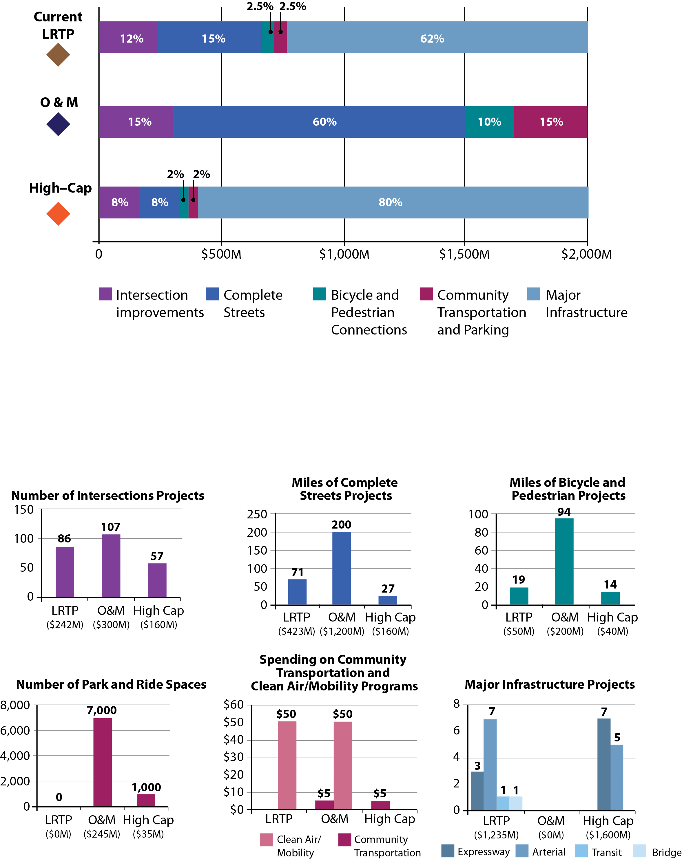
For the alternative scenarios, MPO staff allocated the $2 billion in available funding across five hypothetical programs. The programs (described on the following pages) would address in a thematic way one or more categories of identified transportation needs. The portion of funds allocated to a program depends upon each scenario’s purpose and key characteristics.
Funding Distribution/Projects in Scenarios

The five programs included in the scenarios are described below. The descriptions provide information about how MPO staff estimated costs for types of projects that the program would fund. As shown on the previous page, each scenario allocates different portions of the $2 billion in LRTP funding to each program.
To gauge the scenarios’ performance, staff selected a number of indicators that correspond to the MPO’s goals. To measure programs and projects that could have a regional impact, add capacity to the system, or change an attribute of the system—for example, change the amount of delay or capacity, add an alternative travel option, and so forth—staff utilized the MPO’s regional travel demand model set. Staff used off-model sketch-planning techniques to generate performance data for other projects, particularly those that are lower in cost and have smaller footprints.
Description: Modernizes existing signals or adds signals to improve safety and mobility. Improvements could also consist of turning lanes, shortened crossing distances for pedestrians, and striping and lighting for bicyclists. Improvements to sidewalks and curb cuts also will enhance accessibility for pedestrians. Updated signal operations will reduce delay and improve transit reliability.
Sample intersections for this program, which were used to estimate project benefits, were drawn from the TIP Universe of Projects, locations identified in past MPO studies, and the LRTP Needs Assessment. These projects were prioritized—first through determining if they are high-crash locations to address the MPO’s safety goal, and then if they are located in high-priority-development, environmental justice, or Title VI areas.
Estimated cost of intersection improvement projects: Average of $2.8 million per intersection
Description: Modernizes roadways to improve safety and mobility for all users. Improvements could consist of continuous sidewalks and bicycle lanes, cycle tracks, and other bicycle facilities, as well as updated signals at intersections along a corridor. Improvements will reduce delay and improve transit reliability. Expanded transportation options and better access to transit will improve mobility for all and encourage mode shift.
Estimated cost of Complete Streets projects: $6 million per mile
Description: Expands the bicycle and pedestrian networks to improve safe access to transit, school, employment centers, and shopping destinations. Could include constructing new, off-road bicycle or multi-use paths, improving bicycle and pedestrian crossings, or building new sidewalks.
Sample bicycle and pedestrian projects for this program were selected using evaluated TIP projects, the MPO’s Bicycle Network Evaluation, and bicycle travel market information from the 2011 Massachusetts Household Survey.
Estimated cost of bicycle and pedestrian projects: Varies (analysis uses available preliminary cost, or average of $2 million per mile)
Description: Includes a combination of the following types of projects:
• Community Transportation: Provides funding to launch locally developed transit services that support first-mile/last-mile connections to existing transit services and other destinations by purchasing shuttle buses and/
or funding operating costs. Estimated Cost: Assumed to cost $5 million over the 25-year life of the plan.
• Park-and-Ride: Targets funding to construct additional parking at transit stations that now are at capacity. Estimated Cost: The average cost per parking space is $35,000.
• Clean Air and Mobility Program: Provides funding to projects (such as bike share projects or shuttle bus services) to improve mobility and air quality and promote mode shift.Estimated Cost: Assumed to cost $50 million over the 25-year life of the plan.
Description: Modernizes and/or expands major highways and arterials to reduce congestion and improve safety. Projects could include constructing expressway interchanges to eliminate weaving and reduce the likelihood of rollovers, adding travel lanes on expressways, or adding/removing grade separations on major arterials. The current LRTP also considers transit (Green Line Extension from College Avenue to Mystic Valley Parkway/Route 16) and bridge projects.
Estimated cost per project: Costs were associated with each project based on costs in current or past LRTPs, adjusted to current dollars, or costs from studies that were performed for selected locations, also adjusted to current dollars. Assumes eight interstate bottlenecks and five arterial projects.
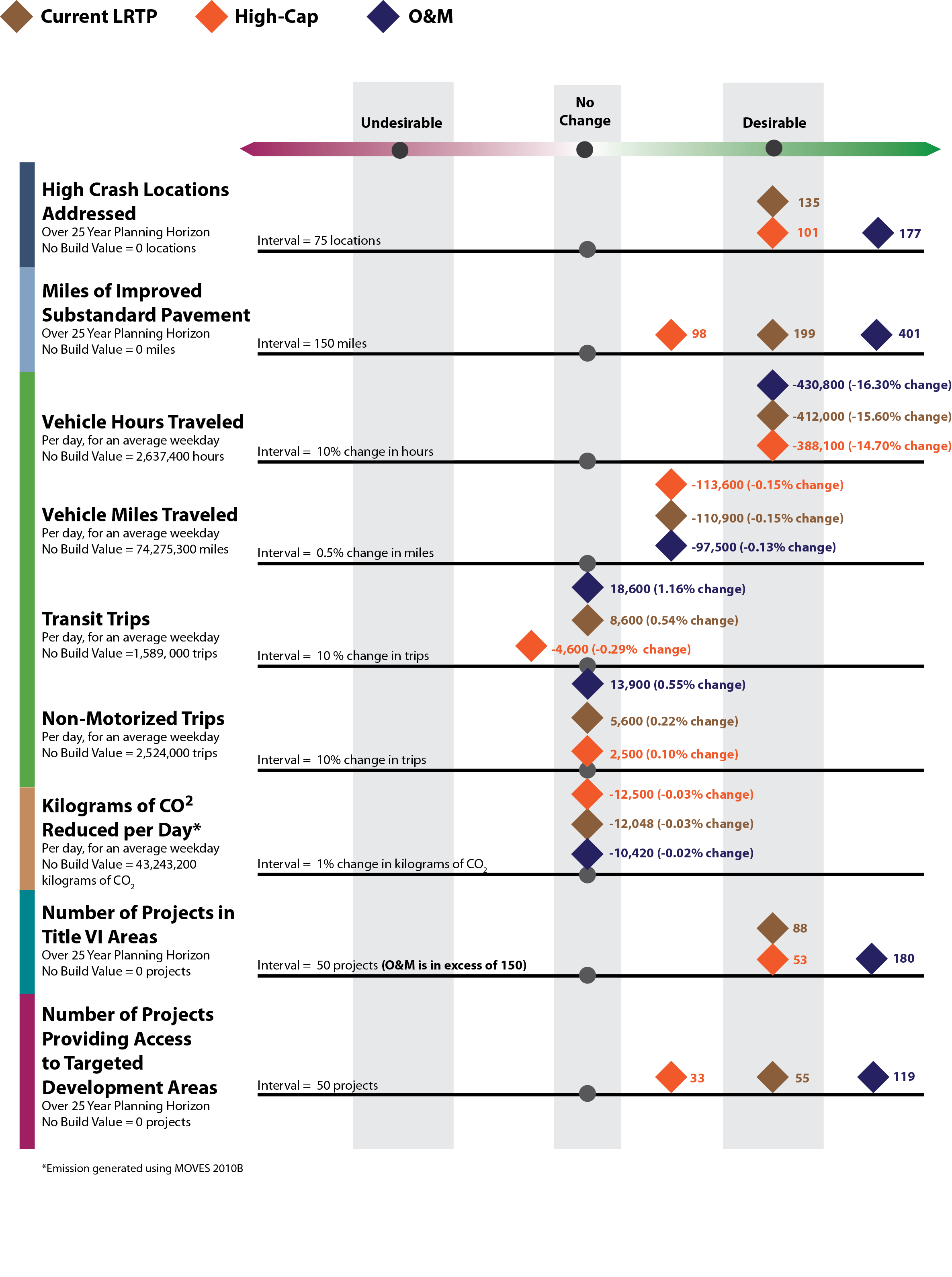
The values for the alternative scenarios are shown relative to the values for the No-Build scenario. When scenario symbols are stacked, the scenarios with symbols toward the top of the stack performed better.

The results of these scenarios provided insight on the MPO’s policy question:
“Should the MPO give priority in a congestion reduction program to major arterials and express highways through the region which serve transit and/or existing population and places of employment?”
The scenario planning results showed how different sets of projects and programs would address the MPO’s goals, including capacity management and mobility. The MPO used these results in conjunction with other information, such as the LRTP Needs Assessment and public feedback, to answer the policy question and develop projects and programs for investing federal funds over the next 25 years. The results show that:
• The O&M scenario is the most effective at addressing a diverse set of MPO goals. It performs similar to or
better than other scenarios that address Capacity Management and Mobility, which is the goal that
members wanted to explore through this planning.
• More than any other, the O&M scenario perhaps provides greater opportunities to ensure geographic
equity (money can be distributed throughout the region, as opposed to being concentrated in a few
specific projects).
• Though all three scenarios performed well in safety—a top-rated MPO goal—the O&M scenario
performed the best. The O&M scenario also performed significantly better than the other two scenario
options in terms of improvements to substandard pavement, which addresses the MPO’s system
preservation goal.
• There is little difference between scenarios in terms of CO2 reduction, and reductions are minor compared
to the “No-build” scenario.
• Similarly, all alternative scenarios create desirable change in terms of vehicle hours traveled, but they do
not differ much from one another. They generate slight desirable change in terms of vehicle miles traveled. In general, under the three scenarios, people are covering the same amount of distance, but spending less
time traveling.
Based on the conclusions from scenario planning, staff recommended that the MPO not adopt the objective of giving priority to a congestion reduction program as posed in the policy question above.
To complete the set of objectives in the Capacity Management/Mobility goal, staff recommended adopting the following revised objective:
“Emphasize capacity management through low-cost investments; give priority to projects that focus on lower-cost O&M-type improvements such as intersection improvements and Complete Streets solutions.”
The implications of this are that the MPO is moving toward a programmatic approach to allocating funding in the LRTP.
Below were questions the MPO considered during its meetings as they finalized Charting Progress to 2040.