The Metropolitan Planning Organization (MPO) corridor studies are part of the Multimodal Mobility and Infrastructure Program. The program goals are to address gaps in regional and community multimodal needs towards a safe and accessible regional transportation system. Staff to the Boston Region MPO prioritized Route 37 in Braintree for study after considering several factors, including the need to address poor safety conditions, the desire to enhance multimodal transportation, and the potential to serve transportation equity populations and prioritize the needs of marginalized communities. This report details the existing conditions, assesses safety and operational problems, discusses improvement options, and recommends implementing improvements. The recommendations, if implemented, would improve safety and multimodal transportation to support the land uses and local businesses along the corridor. In addition, the recommendations would make traffic flow and operations efficient, support bus service, and provide a welcoming environment for people walking, biking, and using assistive mobility devices.
Table of Contents
Executive Summary
Chapter 1 Introduction
Chapter 2 Study Area
Chapter 3 Existing Conditions Assessments
Chapter 4 Proposed Improvements
Chapter 5 Conclusion and Next Steps
TABLES
Table 1 Number of People Biking
Table 2 Intersection Level of Service Criteria
Table 3 Results of the Traffic Signal Warrant Analysis
Table 4 Summary of Intersection Crashes
Table 5 Risk-Based Primary and Secondary Sites in the Corridor
Table 6 Near-Term Improvements in the Granite Street Segment
Table 7 Near-Term Improvements in the Franklin Street Segment.
Table 8 Near-Term Improvements in the Hancock Street and Washington Street Segment
Table 9 Long-Term Improvements in the Granite Street Segment
Table 10 Long-Term Improvements in the Franklin Street Segment.
Table 11 Long-Term Improvements in the Hancock Street/Washington Street Segment
Table 12 Measures of Effectiveness
Table 13 Benefits of Proposed Improvements
FIGURES
Figure 1 Regional Map and Study Area
Figure 2 Segments of Route 37
Figure 3 Transportation Equity Populations
Figure 4 Zoning and Land Use Map
Figure 5 Existing Sidewalks and Crosswalks
Figure 6 Volumes of People Walking
Figure 7 Transit Services Around Route 37, Braintree
Figure 8 Average Weekday Traffic Volumes
Figure 9 2023 Existing Conditions: Peak-Hour Turning Movement Volumes
Figure 10 Existing Conditions: Measured Speeds and Speed Regulations
Figure 11 2023 Existing Conditions: Weekday Peak-Hour LOS and Delays
Figure 12 2023 Existing Conditions: Weekend Saturday Peak-Hour LOS and Delays.
Figure 13 Locations with Excess Expected Crashes: Fatal and Injury (2013–17), Based on MPO Ranking
Figure 14 Typical Destinations for People using Route 37
Figure 15 Locations Where People Feel Unsafe Driving
Figure 16 Locations Where People Feel Unsafe Walking, Biking, or Using Assistive Mobility Device
Figure 17 Projects and Studies Near Route 37
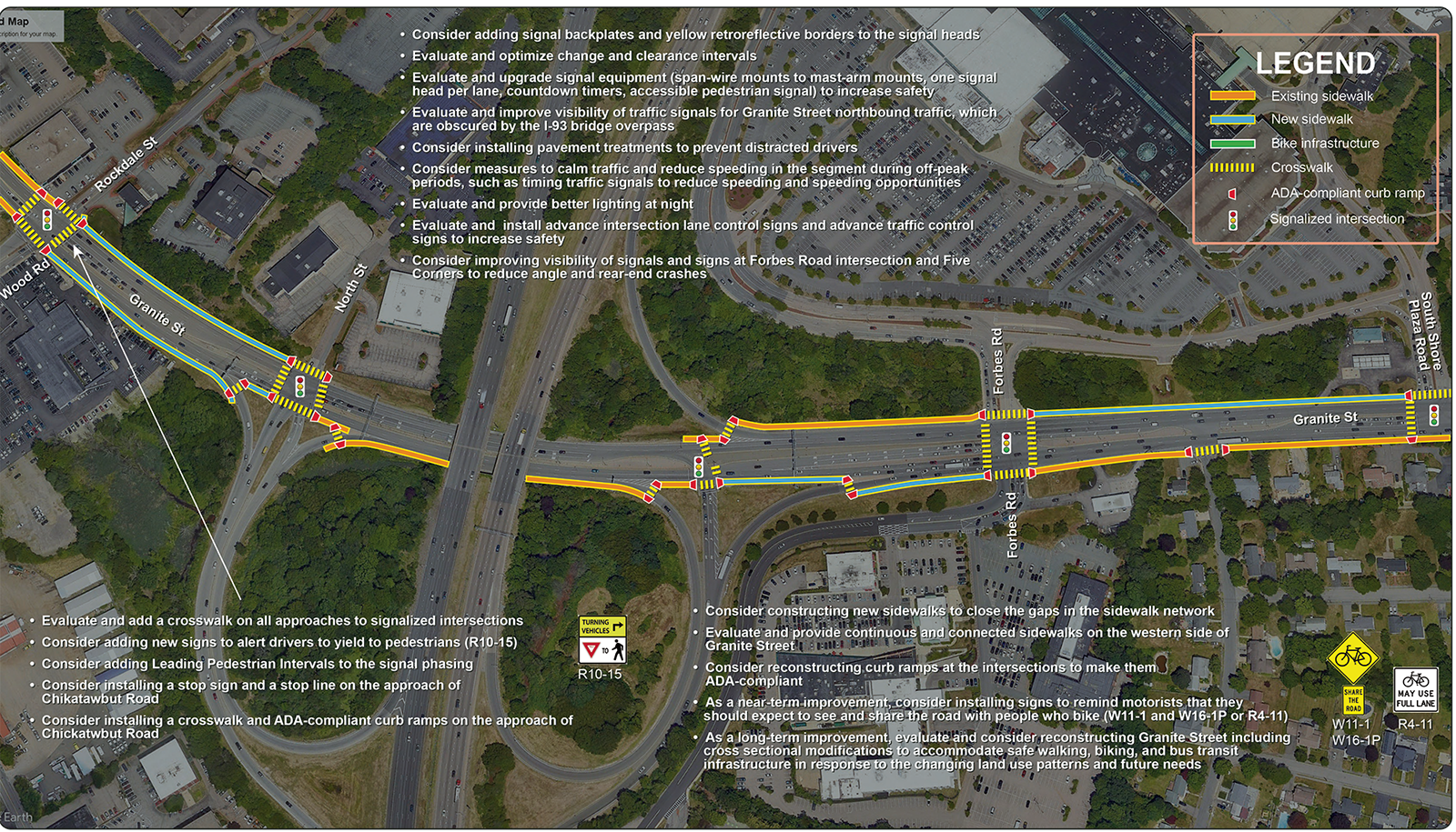
Figure 18 Proposed Improvements for Granite Street Segment.
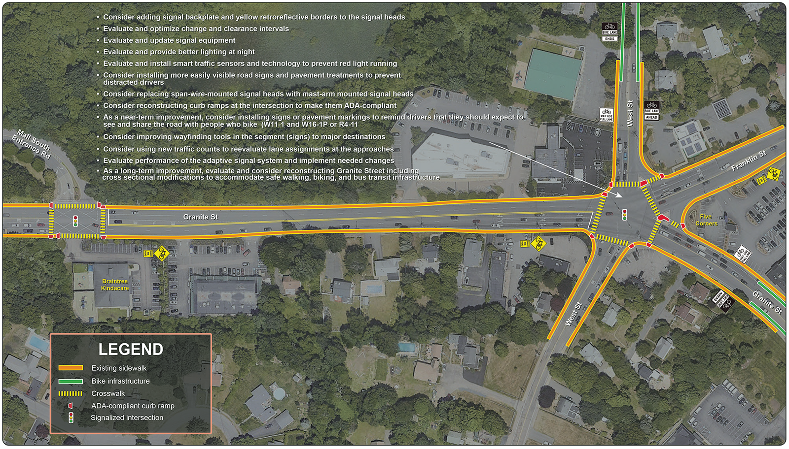
Figure 19 Proposed Improvements at Five Corners
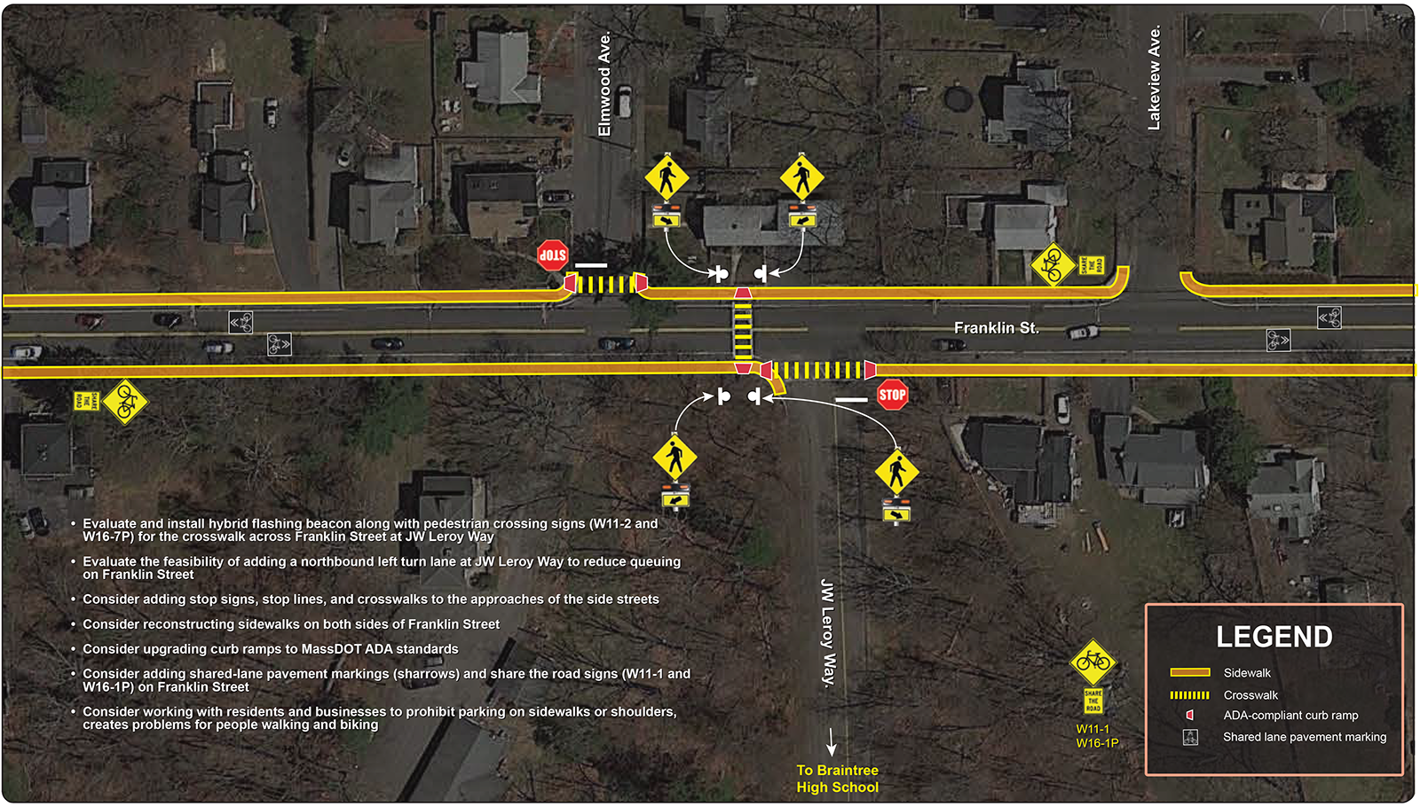
Figure 20 Proposed Improvements at Franklin Street and Leroy Way Intersection
Figure 21 Proposed Improvements: Washington Street from Franklin Street to Pond Street
Figure 22 Proposed Improvements Washington Street, Hancock Street, and Plain Street Intersection
Figure 23 Proposed Cross Section Modifications for Hancock/Washington Streets Segment
Figure 24 Proposed Improvements: Washington Street from Braxton Street to Peach Street
Figure 25 Proposed Improvements: Washington Street at Arbutus Avenue
Figure 26 2035 No-Build Conditions: Weekday Peak-Hour LOS and Delays
Figure 27 2035 No-Build Conditions: Weekend Saturday Peak-Hour LOS and Delays
Figure 28 2035 Build Conditions: Weekday Peak-Hour LOS and Delays.
Figure 29 2035 Build Conditions: Weekend Saturday Peak-Hour LOS and Delays
APPENDICES
Appendix A: Advisory Task Force, Comments, and Selection Process
Appendix B: Pedestrian and Bicycle Levels of Service
Appendix C: Traffic and Signal Timing Data
Appendix D: Intersection Level of Service Analysis
Appendix E: Traffic Safety Data
Appendix F: Community Survey Results
Appendix G: MassDOT Highway Division Project Development Process
Executive Summary
Metropolitan Planning Organization (MPO) corridor studies are part of the Multimodal Mobility and Infrastructure Program. The program goals are to address gaps in regional and community multimodal needs towards a safe and accessible regional transportation system. These gaps include safety, congestion, and multimodal mobility and accessibility issues and the studies focus on exploring strategies to address these challenges and enhance multimodal transportation modes such as increasing safety and quality of infrastructure for nonmotorized modes.
The MPO staff selected Route 37 in Braintree as the subject of a corridor study in the federal fiscal year 2023. The location was prioritized for study after considering several factors, including addressing poor safety conditions and traffic congestion, the desire to enhance multimodal transportation, the potential to serve transportation equity populations and marginalized communities, and the need to maintain regional travel capacity. Past MPO corridor studies include Route 114 in Danvers, Route 203 in Boston, Route 30 in Framingham and Natick, Route 140 in Franklin, Route 16 in Chelsea and Everett, Route 9 in Framingham and Natick, and Route 1 in Norwood. Many of the recommendations from the studies have been implemented. These corridor studies give the municipalities and the Massachusetts Department of Transportation (MassDOT) what would be required to address deficiencies in the corridors before committing to design and engineering. In addition, the studies strive to build consensus among the stakeholders and enhance the planning and design of multimodal transportation infrastructure.
Stakeholder participation was a crucial part of the study. MPO staff used several methods to engage stakeholders in planning improvements to Route 37 Braintree. An advisory committee of representatives from the MassDOT, Massachusetts Bay Transportation Authority (MBTA), Braintree Schools, and South Shore Chamber of Commerce was established to guide this study. Staff met with the advisory committee to kick off the study. In a second meeting, MPO staff presented the existing problems, corridor needs, and ideas for improvements for feedback. This report reflects the committee’s feedback. Appendix A includes a list of task force members and comments.
In addition, staff engaged Braintree residents by launching a community survey to help determine the public’s opinion about concerns and problems on Route 37 and to learn their ideas for resolving them. The online survey, posted on the Town of Braintree's websites, received 300 responses between July and August 2023. The survey questionnaire is included in Appendix A.
With the assistance of the MassDOT Highway Division, MPO staff collected and assembled a wide range of data. Staff analyzed the data, and conducted community surveys to assess the existing conditions, identify the deficiencies, and determine the corridor needs for existing conditions and intended future uses. The process ensures that the recommendations are well informed and that all perspectives are considered.
Key concerns include poor quality sidewalks, pedestrian crossing safety issues, gaps in the sidewalk network, lack of infrastructure for biking, infrastructure noncompliance with the Americans with Disabilities Act (ADA), and high speeds of vehicles that create high-stress levels for people walking or biking. Although there are bikeable shoulders on Route 37, especially on Washington and Hancock Streets south of the corridor, they need to be marked as bike lanes and have consistent width. In addition, the shoulders end near signalized intersections, where they transition into turn lanes. There needs to be a safe transition from bike lanes into shared lanes. In addition, a considerable variation in posted speed limits throughout the corridor (25 miles per hour [mph] to 40 mph) increases stress levels for people biking.
Another key concern for users in the corridor is safety. The corridor has
- two high-crash sites eligible for Highway Safety Improvement Program funding,
- several sites with higher-than-expected number of crashes that must be prioritized for potential safety investments, and
- several top-risk sites involving risk factors such as pedestrian and bicycle, distracted and impaired driving, and younger and older drivers.
People riding the bus are challenged in the corridor in many ways, similar to walking or biking. A critical concern for people who ride the bus is delays, which affect travel time and on-time performance. Improving bus service reliability and infrastructure such as adding bus priority signals, dedicated bus stops, and safe crossing opportunities can increase ridership and prioritize needs of transportation equity populations in the corridor.
MPO staff considered feedback from the advisory committee and input from the community to develop near- and long-term improvements for the corridor.
The near-term improvements are generally low cost, relatively uncomplicated to implement, require minimal design efforts, and typically take fewer than five years to implement. These improvements can be included in some of MassDOT’s corridor projects or through maintenance activities. The near-term recommendations include repairing sidewalks and curb ramps to meet MassDOT standards and comply with the ADA guidelines; adding countdown timers to help expedite safe pedestrian crossings; painting high-visibility crosswalks; repainting faded pavement markings; and installing advance notification signage. Additional near-term improvements include several signal upgrades: retiming signals to reduce congestion, modifying change and clearance intervals to meet MassDOT standards, and adding yellow retroreflective borders to backplates to make the signals more visible at night.
Long-term improvements are generally costly and require more design and engineering efforts. The recommendations for long-term improvements focus on modernizing the roadway to make it safer and multimodal. They include closing substantial gaps in the sidewalk network, adding protected or separated bike lanes, designing bus turnouts into bike lanes, and upgrading signal equipment to include bus priority signals. These long-term improvements and the proposed Braintree Complete Streets Program would increase transportation choices in the corridor to connect people to the office and industrial parks and commercial, educational, and recreational areas.
Conclusion
The improvements and concepts developed in this study provide MassDOT, the Town of Braintree, and other stakeholders an opportunity to review the recommendations for addressing deficiencies in the corridor before committing design and engineering funds to a roadway improvement project. This document provides a guide for possible improvements on this roadway and the necessary information for the project proponents to initiate the project notification and review process. The stakeholders must coordinate with MassDOT to prioritize and advance the recommendations into projects. MassDOT and the Town of Braintree are not obligated to make these improvements.
If implemented, the proposed improvements offered in this report would increase traffic safety, make traffic operations more efficient, and modernize the roadway to accommodate all users. The study aligns with the Boston Region MPO’s goals of increasing safety on the region’s highway system, modernizing roadways to improve capacity and mobility by expanding the quantity and quality of walking and bicycling infrastructure, making transit service more efficient, reducing congestion, and preserving the transportation system.
Chapter 1 Introduction
The Boston Region Metropolitan Planning Organization (MPO) has been conducting studies of roadway corridors identified through the Multimodal Mobility Infrastructure Program as needing improvements to address gaps in regional safety, multimodal transportation, transportation equity issues, and operational problems. The studies strive to build consensus among the stakeholders and enhance the planning and design of multimodal transportation infrastructure. The study's recommendations are sent to implementing agencies, which may fund improvements through various federal, state, and local sources, separately or in combination.
Past MPO corridor studies include Route 114 in Danvers, Route 203 in Boston, Route 30 in Framingham and Natick, Route 140 in Franklin, Route 16 in Chelsea and Everett, Route 9 in Framingham and Natick, and Route 1 in Norwood. Many of the recommendations from the studies have been implemented. Municipalities in the region and the Massachusetts Department of Transportation (MassDOT) have been receptive to these studies, which provide the opportunity to review conceptual options to improve a specific corridor before committing design and engineering funds to a project. Many of the studied corridors have advanced into projects, into construction, or have been implemented.
Suppose a proponent initiates a project that qualifies for state and federal funds. In that case, the study’s documentation may be helpful to both MassDOT and the project proponent for completing MassDOT Highway Division’s project initiation forms, identifying problems along the corridor, justifying the need for improvements, and providing improvement concepts to advance into the preliminary design and engineering stages. MassDOT initiates new projects through a formal three-step process using the Massachusetts Project Intake Tool (MaPIT) to identify the project needs, define project scope (initiation), and submit the project to the project review committee for approval.1
This report is organized into five chapters. Chapter 1 presents an overview of MPO corridor studies and includes a summary of how corridors are selected for study, the goals and objectives for the study, and a summary of the community engagement process. Chapter 2 describes the characteristics of Route 37 and the study area's context. Chapter 3 focuses on evaluating the baseline conditions that will inform the development of the study's purpose and needs. Chapter 4 presents the near-term and long-term corridor improvements that are consistent with the purpose and needs of the corridor and their safety and operational benefits. Chapter 5 focuses on the implementation process to advance the planning study recommendations into projects and the next steps.
The approach to corridor studies begins with the establishment of a universe of corridors. The MPO staff reaches out to the subregional committees, municipalities, and other stakeholders to identify corridors of interest. In addition, MPO staff reviews the Long-Range Transportation Planning Needs Assessment and refers to the MassDOT Impact Portal and GeoDOT, MPO congestion management process, and other tools to identify corridors of interest. Once the universe of corridors is established, MPO staff screens the study locations using established criteria like the Transportation Improvement Program scoring process. Staff prioritizes the corridors based on the following criteria: safety conditions, congested conditions, multimodal significance, regional significance, transportation equity, geographical distribution, and implementation potential.2
Staff selects a corridor for study considering agency, municipal, subregional, and other public feedback. Once staff selects a study location, an advisory task force comprising of the municipality, MassDOT, business chamber/major employers, school district is established to guide the study.
Following the above selection process, MPO staff identified Route 37 in the Town of Braintree for study. The study location was selected from a list of 43 arterial segments in 33 municipalities in the Boston Region MPO area. MassDOT Highway Division District 6, the MassDOT Office of Transportation Planning, the Town of Braintree, Braintree Schools, and the South Shore Chamber of Commerce supported the study by collecting data needed for the analyses and reviewing study documents.
The stakeholders have shown a commitment to improving conditions to transform this corridor into a route that functions for everyone by
- increasing safety for all users;
- improving the quality of walking facilities by repairing poor-quality sidewalks and closing gaps in the sidewalk network so people can walk safely in the corridor;
- incorporating high-quality bike facilities so that people can choose biking as a safe, convenient, and healthy travel mode;
- improving bus reliability and reducing travel time by reducing signal and queue delays and supporting critical first- and last-mile connections;
- improving conditions for transportation equity populations by creating safe, comfortable and accessible bus stops, good-quality sidewalks and bike lanes, and safe crosswalks; and
- supporting economic vitality and livability of the communities along the corridor with multimodal transportation improvements.
Community Engagement
Stakeholder participation is a crucial part of any MPO-sponsored study. Hence, MPO staff used several methods to engage stakeholders in planning improvements for corridor studies. The engagement process began with the study location selection process, during which staff considered agency, municipal, subregional, and other public feedback. An advisory committee composed of staff from MassDOT, Massachusetts Bay Transportation Authority, the Town of Braintree, the South Shore Chamber of Commerce, and Braintree Schools was established to guide the Route 37 corridor study. MPO staff met with the advisory committee to kick off the study. During the kickoff meeting, staff discussed purpose and needs, work scope, tasks and products, and timeline. In a second meeting, MPO staff presented the existing conditions, identified corridor needs and ideas for improvements, and obtained feedback. In addition, MPO staff launched a community survey to help determine the public’s opinion about concerns and problems on Route 37 in Braintree and to learn their ideas for resolving them. This report reflects the advisory committee’s feedback and the community survey results. Appendix A includes a list of task force members and comments.
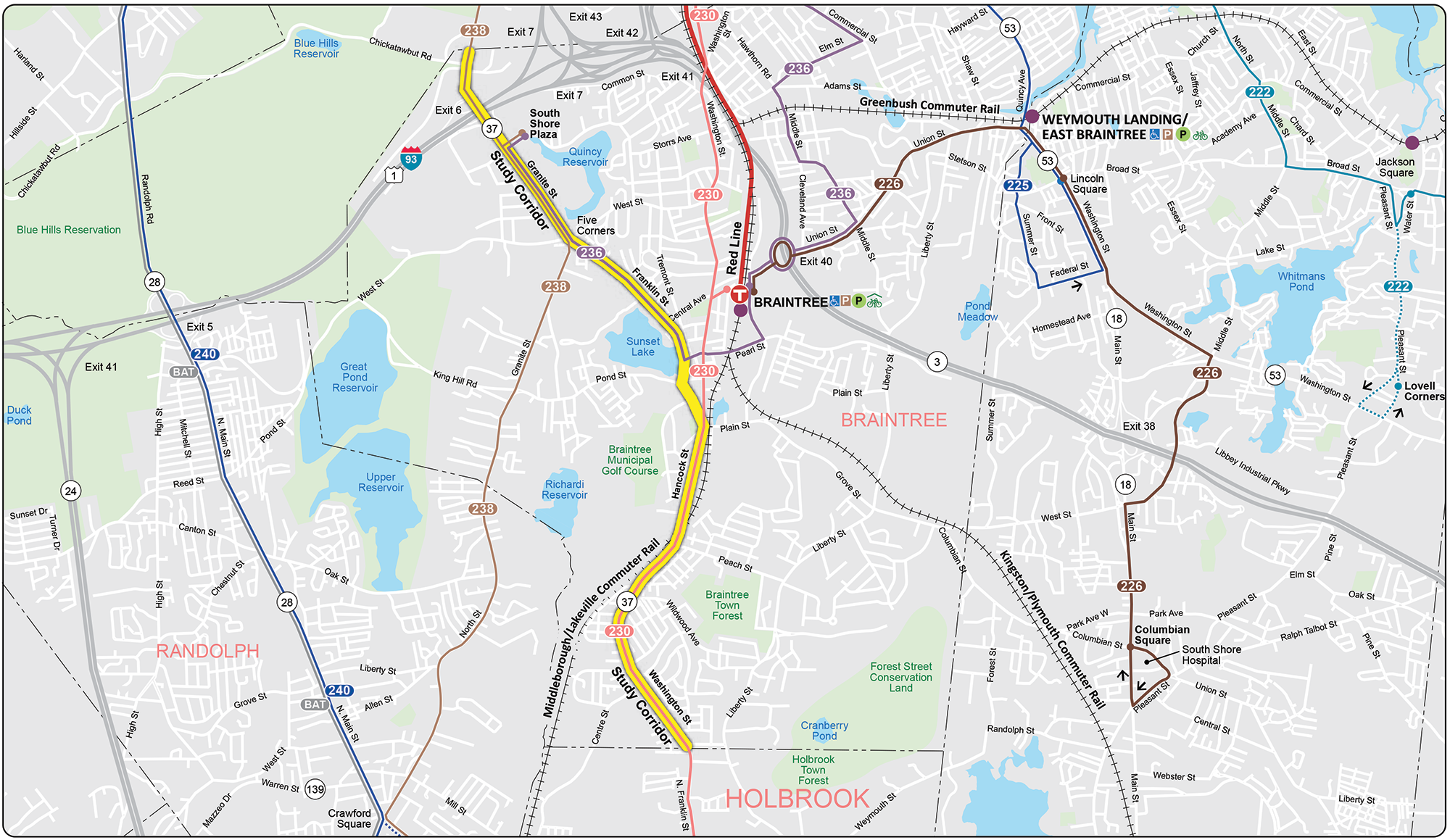
Chapter 2 Study Area
The Town of Braintree is a suburban community located 10 miles south of Boston. The town is situated at the crossroads of Interstate 93 and Route 3, which provide access to the Greater Boston area and Cape Cod. The community has access to public transportation serving Boston and Logan International Airport: the Massachusetts Bay Transportation Authority (MBTA) Red Line; the Lakeville, Middleborough, and Greenbush commuter rail lines; and the Logan Express Braintree Airport Shuttle. Braintree is a mature community of 39,143 residents (as of the 2020 Census) with a broad residential and business base positioned for controlled growth in the future.
Figure 1 shows the study area and surrounding communities and streets. The study area is the half-mile buffer on either side of Route 37 that provides land use and demographic context for the corridor for the existing conditions analysis. The study corridor is the extent of the Route 37 travel corridor in Braintree, from the Quincy city line to the Holbrook town line, including crucial cross streets. Route 37 in Braintree is a state highway. It is classified as an urban principal arterial and is part of the National Highway System. The five-mile-long corridor assumes the local road names of Granite Street, Franklin Street, Washington Street, and Hancock Street. Route 37 is a two-lane, two-way roadway that widens into a four-lane, two-way roadway in the Granite Street segment. It is open to all traffic, including trucks, and its right-of-way width varies between 30 to 40 feet wide in the two-lane sections and 60 to 100 feet wide in the four-lane section. This roadway serves regional and local traffic, carrying between 16,000 and 30,000 vehicles daily. The posted speed limits vary from 25 miles per hour (mph) to 40 mph.
Segments of the roadway have different characteristics and contexts that define needs along the corridor. Route 37 provides access to locations with various land uses, including residential, recreational, educational, industrial, office parks, commercial, and open spaces. The corridor was divided into three segments to reflect these characteristics and contexts: Granite Street, Franklin Street, and Washington/Hancock Street segments (Figure 2).
Figure 1
Regional Map and Study Area

Figure 2
Segments of Route 37

Granite Street Segment
This segment extends 1.3 miles from the Quincy town line to Five Corners (the intersection of Granite, Franklin, and West streets). It is the northern portion of the corridor. Granite Street is a two-way, four-lane roadway that widens at the signalized intersections to accommodate turn lanes. It is open to all traffic, including trucks, and its right-of-way width varies between 60 and 100 feet. It serves multiple land uses, including office and industrial parks, commercial and retail businesses, residential, and open space. The South Shore Plaza, Braintree Hill Office Park, Wood Road Industrial Park, and the commercial businesses at Five Corners are accessible from Granite Street.
The Granite Street segment carries the highest traffic volumes in the corridor (30,000 vehicles daily). An interchange in the segment provides access to I-93 heading north to Boston and surrounding communities, Route 128 heading south to the MetroWest area, and Route 3 heading east to the Cape and Islands. The seven traffic signals in the segment are located at Wood Road, the I-93 northbound and southbound ramp-arterial junctions, Forbes Road, South Shore Plaza Road, and the south mall entrance near Braintree Kindercare. All seven signalized intersections operate with an adaptive traffic control system, in which traffic signal timing changes or adapts based on actual traffic demand. In addition, the segment contains three unsignalized intersections at Chickatawbut Road, Patridge Hill Road, and Davis Road, as well as several commercial and residential driveways.
There are sidewalks on both sides of Granite Street, but they need to be more continuous and connected. The gaps in the sidewalk network cause people walking to switch sides several times to get to their destinations. All marked crosswalks across Granite Street are located at the signalized intersections and are controlled by pedestrian-activated signals. This segment lacks bike lanes, and people biking must share the road with vehicular traffic; however, there are no signs or pavement markings to alert drivers of the presence of people biking. The segment has space constraints because of the significant differences in grades on either side of the roadway, wetlands close to the roadway, and lack of space under the I-93 bridge over Granite Street. MBTA bus service in this segment includes two bus routes: Route 236 Quincy Center Station-South Shore Plaza and Route 238 Quincy Center Station-Randolph
This segment extends 1.4 miles from Five Corners to the Plain Street intersection. It is the middle portion of the corridor and operates as a two-way, two-lane street that widens at the signalized intersection to accommodate turn lanes. Its right-of-way width varies between 30 and 40 feet wide and is open to all traffic, including trucks. The posted speed limits range from 30 mph to 35 mph.
Franklin Street serves multiple land uses, including residential, institutional, commercial and retail businesses, and recreational. Braintree High School, Thayer Academy, Sunset Lake, and the Braintree Municipal Golf Course are in the corridor. Several east-west streets intersect Franklin Street, providing access to other parts of Braintree and beyond.
The segment carries 20,000 vehicles daily and has four signalized intersections at Summer Street, Washington Street, Pond Street, and Plain Street. All four traffic signals operate as isolated signals, and they are not interconnected with each other. Continuous and connected sidewalks are on both sides of Franklin Street, but significant sections need to be in better quality conditions. There are six locations in the segment where people walking can cross Frankin Street: four at the signalized intersections, one at the Leroy Way intersection (unsignalized), and one uncontrolled marked midblock crosswalk near MacMaster Funeral Home. This segment also lacks bike lanes because of space constraints. People biking share the road with vehicles, but there needs to be signs or pavement markings alerting drivers of the presence of people biking. The only bus service in this segment is Route 236.
Route 37 assumes the local names of Hancock Street and Washington Street in the southernmost portion of the corridor. It extends about 2.2 miles from Plain Street to the Holbrook town line. Both streets are two-way, two-lane streets open to all traffic, including trucks. The right-of-way width is about 40 feet wide and includes seven-foot shoulders on both sides of the roadway. Hancock and Washington Streets provide access to multiple land uses, primarily residential. Other uses include commercial, institutional, and recreational. The Braintree Office Park, Highland and Liberty Elementary Schools, South Middle School, Braintree Highland Community Playground, and Cambridge Arts, Technology, and Science Braintree Campus are in the corridor. In addition, the segment serves high volumes of traffic heading to and from Holbrook and beyond.
The Hancock/Washington Streets segment carries traffic volumes similar to the Grant Street segment (25,000 vehicles daily). It has three signalized intersections, several unsignalized intersections, and commercial and residential driveways. The three traffic signals are located at Braxton Street, South Street, and Roosevelt Street and operate as isolated traffic signals. Although the segment has several unsignalized intersections, the primary two are Peach Street and Park Avenue intersections. There are continuous and connected sidewalks on both sides of the roadway, except the western side of Washington Street between Braxton Street and Peach Street. However, a substantial portion of the sidewalks in the northern section from Plain Street to Braxton Street are in poor quality conditions. Bike lanes are present only from the Holbrook town line to Arbutus Avenue, and people biking beyond this section either ride on the sidewalks or the shoulders. The MBTA bus Route 230 runs the entire segment. Route 230 begins at Quincy Center station and operates via Braintree Station busway, Hancock Street, Washington Street, to Montello Station in Brockton.
Chapter 3 Existing Conditions Assessments
Before conducting the existing conditions assessments, a comprehensive data collection plan was prepared, including gathering data from existing databases maintained by the Massachusetts Department of Transportation (MassDOT), the Massachusetts Bay Transportation Authority (MBTA), the Town of Braintree, and the Metropolitan Planning Organization (MPO) for analyses. The data comprise land use information, transportation equity populations, relevant transportation assets such as signals equipment and timing information, sidewalks, and bike lanes. Additional information includes roadway inventory data and studies and projects in the corridor.
MassDOT collected data on roadway users, including volumes and mix of vehicular traffic, people walking or biking, and speeds of vehicles. Data on transit services (bus, rapid transit, and commuter rail) were from the MBTA, including ridership, operating service, and facilities. MPO staff gathered safety data on historical crashes, sites with excess expected average crash frequency, and sites with systemic risk factors such as pedestrian and bicycle-related, younger and older drivers, and impaired and distracted drivers. In addition, MPO staff developed a survey to help determine the public’s opinion about concerns and problems on Route 37 in Braintree and how to resolve them.
The corridor includes several MPO-defined transportation equity zones where residents include low-income and minority populations, younger and older populations, and people with limited English proficiency (Figure 3). These communities are expected to benefit from safety and multimodal improvements, which can help improve quality of life by reducing crashes, increasing physical activity through walking or biking, and improving access to jobs, education centers, and health services
The map in Figure 4 shows the land uses in Braintree. Multiple land uses surround the Route 37 corridor, and land use intensity varies throughout the corridor. Braintree land use patterns are well established, so new uses are expected to be redeveloped or repurposed from existing parcels and properties.
Figure 3
Transportation Equity Populations

Figure 4
Zoning and Land Use Map

The area surrounding the Granite Street segment is zoned a Highway Business District, with large offices and industrial parks located along Wood Road, Rockdale Street, and Forbes Road. Businesses in the office and industrial parks comprise professional, life science and technology, hospitality, entertainment, commercial, and retail services. Also in the segment is the South Shore Plaza, a large shopping mall with multiple retail stores and restaurants.
At the northern end of the Franklin Street segment is the Five Corners, a major commercial center. Businesses at Five Corners include commercial retail services, offices for professional services, banks, and restaurants. Although the area surrounding Franklin Street Segment is zoned residential with single- and multi-family residences, it is mixed with educational, commercial, and recreational uses.
South of the corridor, the Hancock/Washington Streets segment is surrounded by multiple land uses, including residential (dominant uses), educational, open spaces, small-scale commercial retail, and industrial parks.
The Route 37 corridor supports several land uses with the potential to generate and attract walking, biking, driving, and transit trips. Automobiles are the primary access to all the land uses along the corridor. Biking, walking, and bus service accommodations are in the corridor, but they need improvements due to poor quality conditions, gaps and connectivity issues, and limited availability.
Figure 5 shows the locations where there are sidewalks and crosswalks. Sidewalks are present on Route 37 for about 90 percent of its length. However, there are gaps in the sidewalk network on Granite Street, which causes people to use crosswalks to switch sides several times to get to their destinations. In addition, all three roadway segments have poor-quality sidewalk conditions, which create challenges for people walking or using assistive mobility devices. Figure 6 shows walking volumes at the study intersections.
Figure 5
Existing Sidewalks and Crosswalks

Figure 6
Volumes of People Walking

People walking on Route 37 can safely cross it at the signalized intersections, where crosswalks have pedestrian-activated signals and curb ramps. In addition to signalized intersections, people walking can also cross Route 37 at six marked midblock crosswalks across Route 37: one near Park Avenue controlled by a pedestrian signal, one near the Braintree Highland Community Playground controlled by a Rectangular Rapid Flashing Beacon (RRFB), and four near Leroy Way, McMaster Funeral Home near Taylor Street, Peach Street, and Arbutus Avenue that are uncontrolled. Because of the high volumes and speeds of vehicles, some uncontrolled marked crosswalks would need upgrades such as RRFB to improve safety. Together, the spacing between the crosswalks is about as far apart as 0.25 miles (1300 feet) and does not create a barrier between businesses and neighborhoods east and west of Route 37. Table 1 shows the number of people biking. The low number may be attributed to a need for safer biking infrastructure and high vehicle speeds and volumes, which create a high-stress environment and safety concerns for people biking.
Table 1
Number of People Biking
The roadway infrastructure primarily affects the quality of walking and biking travel, such as whether there are sidewalks, crosswalks, curb ramps, or bike lanes. The quality of walking and biking travel is also affected by the character of the roadway and factors that contribute to the safety and security of people, such as the speed and volume of vehicles and comfort and convenience. MPO staff developed LOS tools that grade a given roadway on its quality of walking and biking travel and whether it reflects these objectives: safety, system preservation, capacity management and mobility, and economic vitality.3 Based on this evaluation, the quality of walking on Route 37 was rated poor or fair regarding safety, system preservation, capacity management and mobility, and economic vitality. Bicycle LOS was rated unacceptable regarding safety, system preservation, capacity management and mobility, and economic vitality. The assessment indicates that the roadway needs improvements to safely accommodate people walking and biking. The ratings from this assessment tool are in Appendix B.
People walking and biking in the corridor face several challenges. Following the analysis of crash data, field survey, review of signal data and layouts, and recommendations from road safety audits, these challenges were identified, some of which are summarized below.
- Pedestrian-involved crashes: Five crashes involving people walking along Route 37.
- Gaps in sidewalks: Gaps in the sidewalk network on Granite Street and Hancock-Washington Street segments.
- Poor sidewalk conditions: Uneven sidewalk surfaces, broken with cracks, overgrown vegetation, and obstacles such as utility poles that reduce width to less than four feet. All three segments exhibit these deficiencies.
- Lack of leading pedestrian intervals at signalized intersections with concurrent pedestrian phases (Wood Road intersection).
- Noncompliant Americans with Disabilities Act (ADA) curb ramps: At the I-93 ramp-arterial junctions and intersections of the mall entrances.
- Inadequate street lighting: Poor lighting on Route 37 poses safety and security concerns for people walking.
- Lack of bicycle infrastructure for people biking.
- High-stress environment for people biking due to high vehicle speeds and volumes.
- Issues with bikeable shoulders: Although bikeable shoulders are present on the Hancock/Washington Streets segment, they are not marked as bike lanes.
- Lack of connectivity for bike trips between Route 37 and crossing arterials.
Figure 7 shows the MBTA service in or near the study area, including the Red Line station and commuter rail station at Braintree Station and three bus routes:
- 230 Quincy Center Station-Montello Station
- 236 Quincy Center Station-South Shore Plaza
- 238 Quincy Center Station-Randolph
Braintree station is the southern terminal for one of two Red Line branches and is also a stop on the Middleborough and Kingston commuter rail lines. The station includes a parking garage under construction and contains 1,300 spaces as built and 350 open spaces with additional temporary spaces available at two surface lots on Ivory Street. As of July 2023, Red Line service from Braintree operates every 18 minutes on weekdays and every 22 minutes on weekends. Ridership at Braintree Station on a sample day of September 2022 was 2,630 total boardings, with 1,529 boarding between 6:00 AM and 9:00 AM. On a sample day of April 2023, all-day boardings from Braintree were 1,497, with 651 boarding between 6:00 AM and 9:00 AM due to speed restrictions and a reduction in peak period scheduled service.
The commuter rail service at Braintree station presently consists of 27 inbound and 25 outbound trips to/from Boston on weekdays, 15 of which are from Middleborough and 12 from Kingston. There are 18 inbound and 17 outbound trips on weekends. As mitigation for the Red Line service issues, fare policy changes have significantly increased commuter rail ridership from Braintree Station to Boston. Draft manual counts undertaken by Central Transportation Planning Staff at Braintree station from 6:00 AM to 9:00 AM in July 2023 show more than 600 passengers boarding commuter rail trains to Boston.
Figure 7
Transit Services Around Route 37, Braintree
Route 230 begins at Quincy Center station and operates via Braintree Station busway, Hancock Street, and Washington Street to Montello Station in Brockton. Service operates every 25–30 minutes in the peak, every 60 minutes midday on weekdays and Saturdays, every 75 minutes in the evenings, and every 90 minutes on Sundays. Fall 2022 MBTA total Route 230 ridership data collected from automatic passenger counters was 788 riders on weekdays, 435 on Saturdays, and 260 on Sundays. Fall 2019 average weekday ridership was 1,359. The route has retained 57 percent of 2019 weekday ridership and rising.
Route 236 begins at Quincy Center station and operates via Hancock Street, Washington Street, and Granite Street into South Shore Plaza. Morning rush-hour service only operates between Quincy Center and Braintree station, and the route operates to South Shore Plaza at all other times. Service operates every 60 minutes on midday, PM peak, evenings, Saturdays, and Sundays. Fall 2022 MBTA total Route 236 ridership data collected from automatic passenger counters was 376 on weekdays, 375 on Saturdays, and 243 on Sundays. In Fall 2019, the average weekday ridership was 491. The route has maintained 76 percent of 2019 weekday ridership.
Route 238 begins at Quincy Center station and operates via Hancock Street, Washington Street, Franklin Street, Granite Street, and South Shore Plaza to Crawford Square or Randolph/Holbrook Commuter Rail Station. Service operates every 25 minutes in the AM peak, 65 minutes middays, 40 minutes in the PM peak, 60 minutes on Saturdays, and every 80 minutes on evenings and Sundays.
Fall 2022 MBTA total Route 238 ridership data collected from automatic passenger counters was 965 on weekdays, 648 on Saturdays, and 361 on Sundays. Fall 2019 weekday ridership was 1,438. The route has maintained 67 percent of 2019 weekday ridership and is rising.
People taking bus transit in the corridor face similar challenges for walking and biking. Specific challenges for bus riders are
- on-time performance due to traffic congestion;
- lack of dedicated bus turnouts with accessible features such as curb ramps and crosswalks could present safety problems for riders;
- lack of bus shelters: Only two bus stops in the corridor have bus shelters—at South Shore Plaza and Roosevelt Street. Inclement weather could impact people's decisions to take the bus; and
- lack of bus priority signals to reduce delays and critically congested segments of the corridor.
Driving Mode
MassDOT Highway Division’s Traffic Data Collection collected traffic data for the study. Automatic traffic recorder (ATR) counts were collected from Monday, May 1, 2023, to Friday, May 5, 2023. The ATR counts included daily traffic volumes, speeds, and traffic mix (light and heavy vehicles). MassDOT also collected turning-movement counts (TMC) in the study area on Thursday, May 4, 2023, and Saturday, May 6, 2023. The TMC counts were performed during the weekday AM peak travel period (6:00 AM to 9:00 AM) and weekday PM peak travel period (3:00 PM to 6:00 PM), and during the weekend (11:00 AM to 2:00 PM). In all cases, heavy vehicles, pedestrians, and bicycles were recorded separately. Figures 8 and 9 show the average weekday traffic volumes and the turning-movement volumes at 16 intersections during weekday AM and PM peak hours and the Saturday PM peak hour. Figure 10 shows the measured speeds and posted speed regulations for the corridor. The average speeds are consistent with the posted speed regulations, but the 85th percentile speeds are higher than those of the posted speed regulations in all three segments of the corridor. Speeding is a major concern, especially in the Franklin Street and Hancock/Washington Street segments where residential neighborhoods and schools surround these segments. Many respondents to the community survey commented on this issue. The traffic and speed data are included in Appendix C.
Figure 8
Average Weekday Traffic Volumes

Figure 9
2023 Existing Conditions: Peak-Hour Turning Movement Volumes

Figure 10
Existing Conditions: Measured Speeds and Speed Regulations

MPO staff conducted traffic-operations analyses consistent with the Highway Capacity Manual’s methodologies.4 These methodologies are used to assess traffic conditions at signalized and unsignalized intersections and to rate the LOS from A to F. LOS A represents the best operating conditions (little to no delay). In contrast, LOS F represents the worst operating conditions (long delay). LOS E represents operating conditions at capacity (the limit of acceptable delay). Table 2 presents the control delays associated with each LOS for signalized and unsignalized intersections. Figures 11 through 12 show the analysis results for the weekday AM, weekday PM, and Saturday PM peak periods, respectively. The intersection LOS analyses are included in Appendix D. The following intersections were found to operate under congested conditions and have long queues during peak travel hours.
- Granite Street at Wood Road/Rockdale Street
- Granite Street at Forbes Street
- Granite Street at Franklin Street and West Street (Five Corners)
- Washington Street at Franklin Street
- Washington Street at Plain Street and Hancock Street
- Washington Street at Peach Street
Table 2
Intersection Level of Service Criteria
|
Improvements |
Safety Benefit |
Reference |
Install rectangular rapid flashing beacon |
Up to 47 percent reduction in pedestrian crashes |
(CMF ID: 9024) NCHRP Research Report 841 Development of Crash Modification Factors for Uncontrolled Pedestrian Crossing Treatments, (2017). |
Install pedestrian hybrid beacon |
Up to 55 percent reduction in pedestrian crashes
Up to 29 percent reduction in total crashes
Up to 15 percent reduction in severe injury and fatal crashes
|
(CMF ID: 9020) Zegeer et al. NCHRP Report 841: Development of Crash Modification Factors for Uncontrolled Pedestrian Crossing Treatments. TRB, (2017).
(CMF ID: 2911, 2917) Fitzpatrick, K. and Park, E.S. Safety Effectiveness of the HAWK Pedestrian Crossing Treatment, FHWA-HRT-10-042, (2010) |
Provide pedestrian countdown timers |
Up to 9 percent reduction in all crashes |
(CMF ID: 8790) Kigali, A. et al. "Developing Crash Modification Factors to Quantify Impacts of Pedestrian Countdown Signals to Drivers." Presented at the 96th Annual Meeting of the Transportation Research Board, Paper No. 17-05178, Washington, D.C., (2017 |
Install high-visibility crosswalk |
Up to 40 percent reduction in pedestrian injuries |
(CMF ID: 4123) Chen, L., C. Chen, and R. Ewing. The Relative Effectiveness of Pedestrian Safety Countermeasures at Urban Intersections - Lessons from a New York City Experience. (2012). |
Improve highway lighting |
Up to 28 percent reduction in nighttime injury crashes. |
(CMF ID: 436) Elvik, R. and Vaa, T. Handbook of Road Safety Measures. Oxford, United Kingdom, Elsevier, (2004). |
Improve intersection lighting |
Up to 42 percent reduction in pedestrian crashes.
Up to 38 percent reduction in nighttime crashes
|
(CMF ID: 436, 433, 192) Elvik, R. and Vaa, T. Handbook of Road Safety Measures. Oxford, United Kingdom, Elsevier, (2004)
(CMF ID: 2376) Ye et al. A Simultaneous Equations Model of Crash Frequency by Collision Type for Rural Intersections, 87th Annual Meeting of the Transportation Research Board, (2008). |
Install advance yield or stop marking. |
Up to 25 percent reduction in pedestrian crashes |
(CMF ID: 9017) Zeeger et al. Development of Crash Modification Factors for Uncontrolled Pedestrian Crossing Treatments, FHWA, (2017). |
Provide sidewalks |
Up to 40 percent reduction in pedestrian crashes. |
(CMF ID: 11246) Abou-Senna et al. Investigating the correlation between sidewalk and pedestrian safety, 2022. |
Implement road diets |
Between 19 percent and 47 percent reduction in total crashes |
(CMF ID: 5554, 2841) Evaluation of Lane Reduction “Road Diet” Measures on Crashes, FHWA-HRT-10-053, (2010). |
Provide roadway shoulders |
Up to 71 percent reduction in crashes involving pedestrians walking along roadways. |
Gan et al. Update of Florida Crash Reduction Factors and Countermeasures to Improve the Development of District Safety Improvement Projects. Florida DOT, (2005). |
Install leading pedestrian intervals |
Up to 13 percent reduction in pedestrian-vehicle crashes at intersections. |
(CMF ID: 9918) Goughnour, E. et al. "Safety Evaluation of Protected Left-Turn Phasing and Leading Pedestrian Intervals on Pedestrian Safety." Report No. FHWA-HRT-18-044. Federal Highway Administration. (October 2018) |
Install bike lanes |
Converting traditional or flush-buffered bicycle lanes to separated bicycle lanes with flexible delineator posts can reduce bicycle/vehicle crashes by up to 53 percent.
Bicycle lane additions can reduce crashes by up to 49 percent on urban four-lane undivided collectors and local roads. |
(CMF ID: 11296) Developing CMFs for Separated Bicycle Lanes. FHWA-HRT-23-025, (2023).
(CMF ID: 10738, 10742) Development of Crash Modification Factors for Bicycle Lane Additions While Reducing Lane and Shoulder Widths. FHWA-HRT-21-012, (2021).
|
Add stop signs/stop lines |
Up to 10 percent reduction in total crashes
Up to 37 percent reduction in injury and fatal crashes |
(CMF ID: 8867, 8870, 8874, 8893) T. Le et al. "Safety Effects of Low-Cost Systemic Safety Improvements at Signalized and Stop-Controlled Intersections," 96th Annual Meeting of the Transportation Research Board, Paper Number 17-05379, January 2017. |
Modify clearance/ change times to ITE standards |
Up to 50 percent reduction in red light running.
Up to 14 percent reduction in all crashes
|
(CMF ID: 380, 384) NCHRP Report 731: Guidelines for Timing Yellow and All-Red Intervals at Signalized Intersections, (2011). |
Add yellow retroreflective borders to signal heads |
Up to 15 percent reduction in nighttime crashes |
Sayed, T., Leur, P., and Pump, J., “Safety Impact of Increased Traffic Signal Backboards Conspicuity.” 2005 TRB 84th Annual Meeting: Compendium of Papers CD-ROM, Vol. TRB#05-16, Washington, D.C., (2005). |
Conduct road safety audits |
Between 10 percent to 60 percent reduction in crashes |
Road Safety Audits: An Evaluation of RSA Programs and Projects, FHWA-SA-12-037; and FHWA Road Safety Audit Guidelines, FHWA-SA-06-06 |
Provide high-surface friction treatment |
Up to 20 percent reduction in crashes at intersections
Up to 48 percent reduction in crashes at horizontal curves
|
(CMF ID: 10342,10333) Merritt et al. Development of Crash Modification Factors for High Friction Surface Treatments. FHWA, (2020).
(CMF ID: 2259) NCHRP Report 617: Accident Modification Factors for Traffic Engineering and ITS Improvements, (2008)
|
Provide dedicated turn lanes |
28 percent to 48 percent reduction in crashes for the left turn lane
14 percent to 26 percent reduction in total crashes in the right turn lane |
(CMF ID: 260, 268, 285, 289) Harwood et al. Safety Effectiveness of Intersection Left- and Right-Turn Lanes. FHWA-HRD-02-089, (2002).
(CMF ID: 6096) Persaud et al. Safety Evaluation of Offset Improvements for Left-Turn Lanes. FHWA-HRT-09-035, (2009).
|
Implement speed management |
Appropriate Speed Limits for All Road Use |
|
Implement transit signal priority |
Up to 12 percent reduction in all crashes |
CMF ID: 11232) Ali, MD. S.et al. Quantifying the Safety Benefits of Transit Signal Priority Using Full Bayes Before–After Study. Journal of Transportation Engineers, Part A: Systems, Vol. 148 (1): 04021102, (2022). |
Improve signal visibility |
Up to 13 percent of all crashes |
(CMF ID 1433) Sayed, T. et al. "Evaluating the Safety Impacts of Improving Signal Visibility at Urban Signalized Intersections." 2007 TRB 86th Annual Meeting: Compendium of Papers CD-ROM, Vol. TRB#07-135, Washington, D.C., (2007)
(CMF ID 1411-13) El-Basyouny et al. "Investigating the Effect of Collision Aggregation on Safety Evaluations using Multivariate Linear Intervention Models: Case Study of Signal Head Upgrade Program." Presented at the Transportation Research Board 91st Annual Meeting, Paper No. 12-2093, January 22-26, 2012. |