Technical Memorandum
DATE: May 18, 2017
TO: John DePriest, Planning and Development Director, City of Chelsea
FROM: Chen-Yuan Wang and Katrina Crocker, MPO Staff
RE: Safety and Operations Analyses at Selected Intersections, FFY 2016—Chelsea, Broadway at Fourth and Fifth Street
This memorandum summarizes the analyses and improvement strategies for two intersections in Chelsea: Broadway at Fourth Street and Broadway at Fifth Street, which were selected through a comprehensive review of 20 potential study locations in the region.1
The memorandum contains the following sections:
It also includes technical appendices that contain data and methods applied in the study.
The purpose of the Safety and Operations Analyses at Selected Intersections study is to examine safety, operations, and mobility issues at major intersections in the Boston Region Metropolitan Planning Organization (MPO) area’s arterial highways—where many crashes occur, and which experience congestion during peak traffic periods, or are in need of improvements for bus, bicycle, and pedestrian travel. For the past ten years, the MPO has been conducting these planning studies, and municipalities in the region are very receptive to them, as the studies give communities an opportunity to begin looking at the needs of problematic locations at the conceptual level, before they commit funds for design and engineering. Eventually, if the project qualifies for federal funds, the study’s documentation also is useful to the Massachusetts Department of Transportation (MassDOT). These studies support the MPO’s visions and goals, which include increasing transportation safety, maintaining the transportation system, advancing mobility, and reducing congestion.
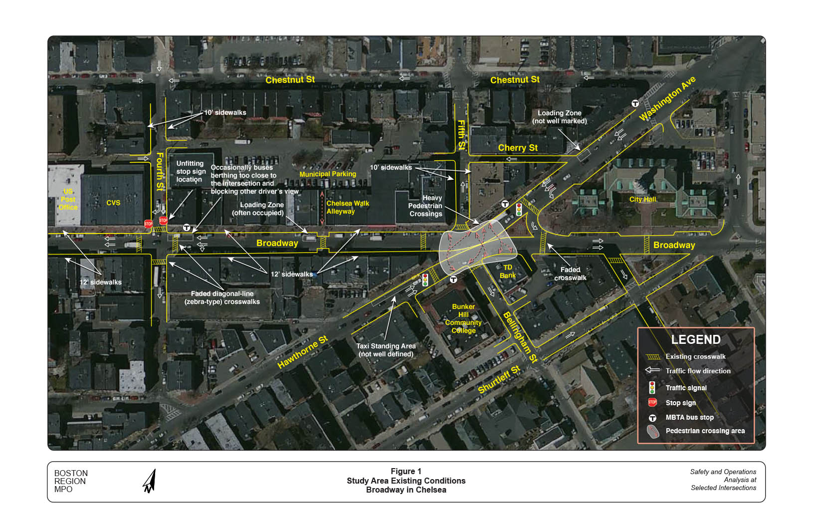
The two intersections discussed here are located in Chelsea’s downtown area, where major roadways and Massachusetts Bay Transportation Authority (MBTA) bus routes converge. The area is a busy business district with intensive activities generated by pedestrians, bicycles, vehicles, buses, truck deliveries, and on-street parking. Figure 1 shows the locations of the two intersections, existing street layouts, and major developments in the study area.
Broadway at Fifth Street, locally known as Bellingham Square, is the busiest intersection in the city in terms of pedestrian activities. In addition to many local and franchised businesses, the City Hall complex and a branch campus of Bunker Hill Community College are adjacent to the intersection. The square also is the city’s bus hub. Two major MBTA bus stops, one for inbound trips on Broadway near Fifth Street and one for outbound trips on Hawthorne Street in front of Bunker Hill Community College, serve riders for MBTA Routes 111, 112, 114, 116, and 117. Buses arrive frequently during peak commuting hours. The stop on Broadway is tight for berthing two buses. If a bus occupies the middle of the allotted space, the second bus is usually double-parked.
The streets at this intersection all operate one-way only. Two main streets, Washington Avenue/Broadway (westbound only) and Hawthorne Street/Broadway (eastbound only), are separated by a strip of concrete pavement to prohibit traffic (except emergency vehicles) from crossing. Two minor streets, Fifth Street (northbound only) and Bellingham Street (southbound only), carry traffic leaving the intersection. The main streets each carry two lanes of traffic, with on-street parking on both sides; the minor streets each carry one lane of traffic, with on-street parking on one side.
Crosswalks exist at all legs of the intersection. The diagonal-line (zebra-type) crosswalks are mostly faded from heavy vehicle traffic. The crosswalks are not fully used by pedestrians; and many people cross freely in the wide intersection outside the marked crosswalks (see Figure 1). Recent counts recorded as many as 500 or more pedestrians crossing outside of the crosswalks per peak hour.
This signalized intersection operates in a simple two-phase mode—one for traffic and one for pedestrians—in approximately one-minute signal cycles. The 21-second pedestrian phase is tight for seniors and children crossing the Washington Street approach. Staff observed pedestrians crossing Washington Avenue, Broadway, and Hawthorne Street without waiting for pedestrian signal phases.
Broadway at Fourth Street, about 600 feet west of Fifth Street, is an unsignalized intersection with stop control on Fourth Street. Broadway operates one-way westbound and Fourth Street operates one-way southbound. Approaching the intersection, Broadway has two travel lanes: one for through movements and one shared by through- and left-turn movements. Fourth Street has two lanes: one for right turns and one for through movements. Broadway is generally busy during peak hours. Fourth Street, connecting to US Route 1 about 500 feet north, carries heavy traffic during PM peak hours; and because of the stop sign control, drivers endure delays and tend to enter the intersection aggressively.
This intersection carries a large number of pedestrian crossings. Crosswalks exist on all four legs of the intersection, but they are located too far from the intersection. Because of the buildings at the intersection corners, drivers have a hard time seeing pedestrians in the crosswalks, especially those turning left from Broadway; and a number of crashes have caused pedestrian injuries at the crosswalk on the south side of the intersection.
An MBTA bus stop, with a shelter and a bench, is located at the northeast corner of the intersection. As the bus berth is not well defined, buses often stop too close to the intersection, blocking the view of drivers from Fourth Street and preventing them from seeing traffic and pedestrians on Broadway. In addition, the shelter and the bench occupy almost half of the sidewalk width, impeding pedestrians.
The section of Broadway between Fourth and Fifth Streets operates as two-lane westbound only, with on-street parking on both sides. Twelve-foot sidewalks exist on both sides of Broadway alongside stores that are popular with local and regional residents, which makes for very busy pedestrian and vehicular traffic during the evening and Saturday midday peak hours.
A municipal parking lot is located behind the buildings north of Broadway. Although this lot provides the downtown area with additional parking spaces, there is no signage to indicate its location or direct visitors. The parking lot can be accessed only from Cherry Street or Fourth Street. A pedestrian alleyway, Chelsea Walk, connects the parking lot to Broadway
A mid-block crosswalk on Broadway at Chelsea Walk serves pedestrian crossings in the entire section. At both ends of the crosswalk, sidewalks are suitably extended to Broadway. However, the crosswalk is not clearly visible to drivers because it is too narrow, contains faded diagonal lines, and lacks visual forewarning cues.
Currently, there are no dedicated bicycle facilities on Broadway and adjacent side streets; and although there are fewer cyclists than pedestrians, they still are active in the downtown area. Besides commuting trips, many of them appear to be local shopping and recreational trips to downtown or nearby neighborhoods. Staff observed some bicycles traveling in the opposite direction of traffic, as well as on sidewalks.
Based on MPO staff’s field observations, recently collected data and discussions with the Chelsea Department of Planning and Development, major issues and concerns in the study area are:
To support this study, MassDOT collected 24-hour traffic volumes on study area roadways, peak-period turning-movement counts at the two intersections (including pedestrian and bicycle volumes), and pedestrian crossing counts at Bellingham Square.
MassDOT collected 24-hour traffic volumes during the weekday period, April 12 to 15, 2016 at five locations in the study area. The data indicate that, on average, approximate weekday traffic volumes were as follows2 :
Appendix A contains 24-hour counts (summarized in hours) for the five count locations.
MassDOT collected turning movement counts during the morning peak period (7:00–9:00 AM) and the evening peak period (4:00–6:00 PM) on Thursday April 14, 2016, and during the midday peak period (12:00–2:00 PM) on Saturday April 16, 2016, in 15-minute intervals. MassDOT also collected data on the numbers of pedestrians crossing at Bellingham Square (without using the crosswalks) during the same AM, PM, and Saturday midday peak periods.
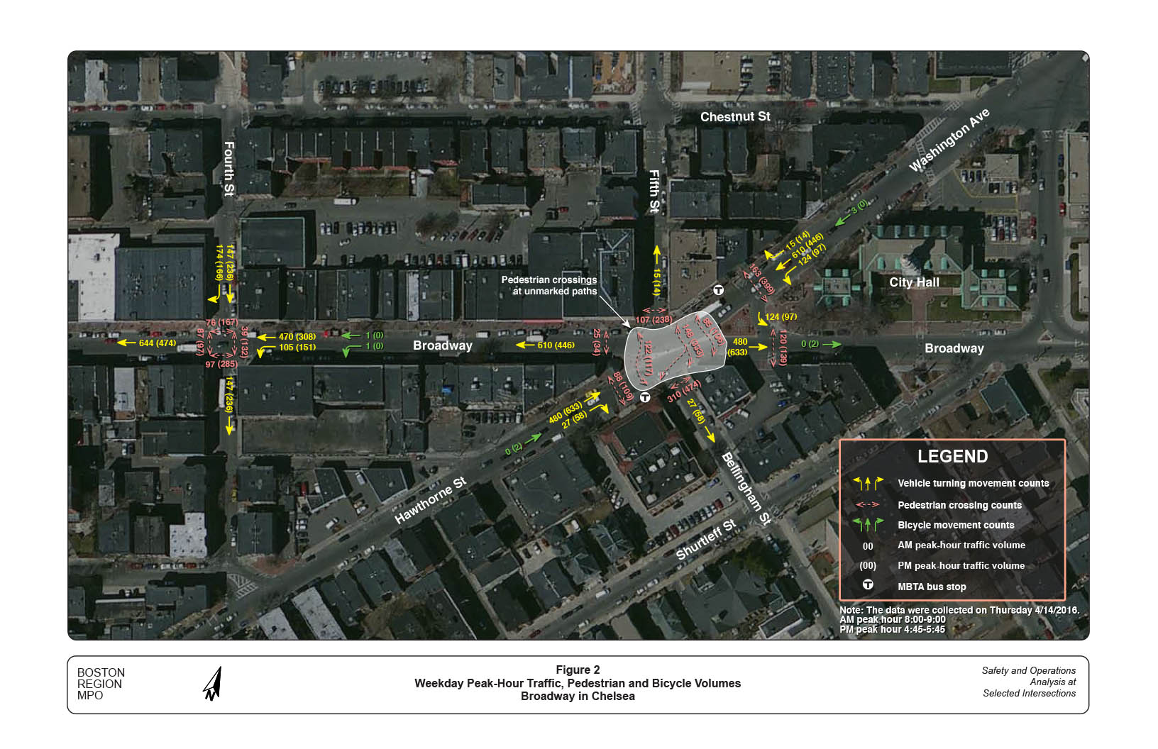
Figure 2 shows the weekday morning (8:00–9:00) and evening (4:45–5:45) peak-hour traffic, pedestrian, and bicycle volumes at the two intersections. The Fifth Street intersection carried about 1,250 vehicles in the AM peak hour: 749 from Washington Avenue and 507 from Hawthorne Street. In the PM peak hour, it also carried about 1,250 vehicles: 557 from Washington Avenue and 691 from Hawthorne Street. The counts include 61 buses and 37 trucks in the AM peak hour and 61 buses and 8 trucks in the PM peak hour. Appendix B shows the intersection turning movement counts at by vehicle class, and number of bicycles and pedestrians.
Pedestrian crossings were intensive at the Fifth Street intersection, especially in the PM peak hour. Nearly 1,200 pedestrian crossings occurred in the AM peak hour and nearly 2,000 crossings occurred in the PM peak hour. About two-thirds of total crossings (800 in the AM and 1,300 in the PM peak hour) were on Broadway. These crossings occurred at various locations including marked crosswalks on four major legs of the intersection and three unmarked but roughly identifiable paths on Broadway between Washington Avenue and Hawthorne Street. Crossings at the unmarked paths (see Figure 2) count for nearly half of the total Broadway crossings (more than 350 in the AM and more than 550 in the PM). The middle path, diagonally located between the inbound and the outbound bus stops, carried many more crossings than the other two locations. Appendix C shows the hourly pedestrian crossing counts at the three different paths.
The counts show only about two to three on-road bicycles passing through the intersection in both the AM or PM peak hours. Note that cyclists generally are less active in April when the weather is still cold; and that, presumably, bicycle volumes would be higher between May and October. A field trip in November observed more than three bicycles on the road and one on the sidewalk between 3:00 and 4:00 PM.
The Fourth Street intersection carried about 900 vehicles in the AM peak hour: 575 from Broadway and 321 from Fourth Street, and about 850 vehicles in the PM peak hour: 459 from Broadway and 402 from Fourth Street. Note that the counts include 39 buses and 18 trucks in the AM peak hour, and 32 buses and 11 trucks in the PM peak hour.
The intersection also carried heavy pedestrian crossings, especially in the PM peak hour. Nearly 300 pedestrian crossings occurred in the AM peak hour, and nearly 700 crossings occurred in the PM peak hour. Only two bicycles were observed in the AM peak hour. Appendix D shows the intersection turning movement counts by vehicle class, and number of bicycles and pedestrians.
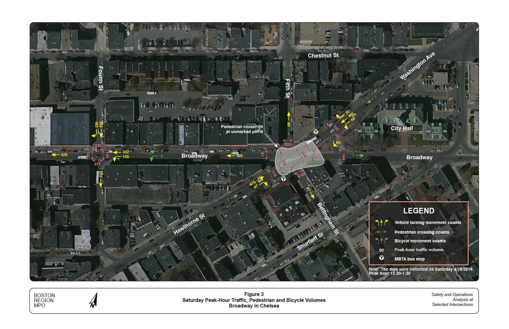
Figure 3 shows the Saturday midday peak-hour (12:30–1:30 PM) traffic, pedestrian, and bicycle volumes at the two intersections. The Saturday counts are similar to the weekday PM peak-hour counts in terms of volumes and movement patterns. The Fifth Street intersection posted about 1,800 pedestrian crossings. The Fourth Street intersection posted about 800 pedestrian crossings, and more than that in the weekday PM peak hour. The Saturday turning movement counts by hour are included in Appendices B and D separately for the two intersections.
Based on the collected turning movement counts, staff conducted traffic operational analyses for the two intersections using the Synchro traffic analysis and simulation program.3 Staff also examined the existing and required pedestrian crossing times at different locations, and bicycle and bus operating conditions.
At the Fifth Street intersection, traffic signals and pedestrian crossing signals exist only on the Washington Avenue and Hawthorne Street approaches. The two traffic signals operate synchronously under one controller. Each 61-second signal cycle consists of a 40-second traffic phase and a 21-second pedestrian phase. The signal setting operates 24 hours continuously.
The Synchro analyses indicate that traffic operates at desirable level of service (LOS) B or better, with an average delay of 8 to 10 seconds, on both the Washington Avenue and Hawthorne Street approaches in all three different peak hour periods (AM, PM, and Saturday). Appendix E contains the three peak-hour intersection capacity analyses under existing conditions.
Staff also analyzed traffic operations using predicted 2040 traffic conditions, assuming 15 percent traffic growth from existing volumes.4 The analyses indicate that traffic still would operate at desirable LOS B or better, with an average delay of 10 to 12 seconds, in all three peak-hour periods using the existing signal setting.
The analyses did not include traffic congestion and delays caused by the large number of pedestrian crossings, especially those outside of crosswalks and during traffic signal phases. Frequent bus arrivals and departures are the source of even more traffic delays; and Synchro simulations could not fully reflect these conditions, except for showing occasional pedestrian crossings during traffic phases. Based on field observations, staff consider that the existing traffic more likely operates at LOS C, with an average delay of about 15 to 20 seconds.
The existing 21-second pedestrian signal phase is sufficient for pedestrians to cross only one leg of the crosswalks on Washington Avenue, Broadway, or Hawthorne Street. It is tight for seniors and pedestrians with young children to cross the nearly 45-foot-long crosswalk on Washington Avenue or Broadway eastbound. Applying a 3.0-feet per-second walking speed and a 7-second “walk” start-up time, it would barely meet the required total signal time to cross the Washington Avenue.5
The 21-second time is not intended to pertain to crossing outside of the crosswalks, or the entire length of Broadway. The shortest distance on Broadway between Washington Avenue and Hawthorne Street is about 55 feet. Those who cross Broadway using the shortest path cannot see the pedestrian signals; they usually cross Broadway when they see traffic stopping. Often when traffic starts to move, they are only halfway through, and thus stuck in the middle of Broadway. The pedestrian counts indicate that there is a strong demand for adequate pedestrian crossing facilities in this section of Broadway, which also would provide safe and convenient access to MBTA buses.
Synchro analysis indicates that traffic at the Fourth Street intersection operates at acceptable LOS E only in the AM peak hour and at LOS F with an average delay of more than two minutes in the PM and Saturday peak hours. Appendix F contains the three peak-hour intersection capacity analyses under existing conditions.
Using the predicted 2040 traffic conditions, the Fourth Street approach would operate at LOS F in the AM with an average delay of more than one minute. The PM and Saturday peak-hour conditions would deteriorate severely. The analyses also did not fully reflect traffic congestion and delays caused by the large number of pedestrian crossings and frequent bus blockages.
Staff conducted a preliminary signal warrant analysis and found that the intersection potentially could qualify for a traffic signal installation. Even though the intersection has a large number of pedestrian crossings, it does not meet the Pedestrian Volume warrant (Warrant 4) because traffic volume on its main street (Broadway) is not relatively significant. It would meet the Crash Experience warrant (Warrant 7), based on the assumption of five or more correctible crashes per year. Appendix G presents this analysis based on recent traffic counts.
Future improvements at the two intersections also should include bicycle accommodations. Staff recommend that both separated- and shared-lane bicycle operations should be explored; and selecting the best option also would require examining right-of-way conditions beyond the Broadway section. At this preliminary stage, it appears that the shared-lane operation is more suitable because, in the study area, Broadway has a limited surface width and a 25-mile per-hour speed regulation, which is applicable for shared-lane bicycle operations.
The recent MassDOT Crash Locations report indicates that the Chelsea downtown area is the number one pedestrian crash location in the state based on 2004–13 crash data. In the ten-year period, there were 236 crashes, including one fatal and 176 involving injury. The crash cluster and crash locations map (Appendix H) indicates that the study area, Broadway from Bellingham Square to Fourth Street, had the greatest concentration of pedestrian crashes within the crash cluster.
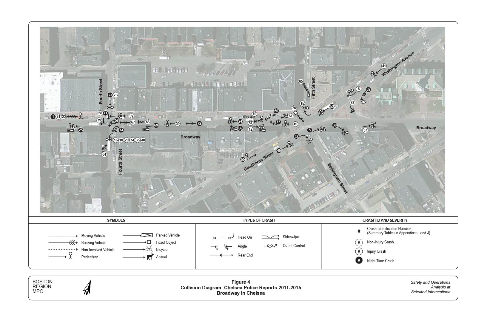
Figure 4 shows the locations and patterns of crashes in the study area from 2011 to 2015. Staff constructed the collision diagram based on data from a recent MassDOT Road Safety Audit (RSA) in downtown Chelsea6 and additional data collected from Chelsea Police Department. The RSA study focused on pedestrian and bicycle crashes (involving at least one vehicle and a pedestrian or cyclist). To portray the crash conditions thoroughly, staff collected vehicle-to-vehicle and other single-vehicle crashes in the same time period.
Appendix I contains information about the crashes from the RSA study, which covered a larger area of Broadway than did this study. Appendix J contains additional information about the crashes from Chelsea Police Department data. Staff transferred identification numbers (1–56) of the crashes from the RSA directly and added new numbers for the police department data (57–79).
The collision diagram shows that 45 crashes occurred in the five-year period—22 pedestrian and bicycle crashes, and 23 vehicle-to-vehicle and single-vehicle crashes. Two-thirds (30) of these crashes, mostly involving a pedestrian or cyclist, resulted in personal injuries.
At the Fifth Street intersection, 16 crashes occurred in the five-year period, including seven pedestrian crashes (four crossing Broadway), and three bicycle crashes (two crossing Broadway and one traveling in the direction opposite of traffic). The pedestrian and bicycle crashes all resulted in personal injuries. The other crashes were all related to parking maneuvers, except a two-vehicle sideswipe collision and an out-of-control single vehicle crash.
At the Fourth Street intersection, 22 crashes occurred in the five-year period, including 12 pedestrian crashes (six at the crosswalk on the south side, four crossing Broadway, and two at the crosswalk on the north side) and one bicycle crash with a parked vehicle. All but two of the pedestrian crashes resulted in personal injuries. Four vehicle-to-vehicle crashes occurred on Broadway westbound, and three collisions involved a westbound vehicle and a southbound vehicle.
Under stop control, Fourth Street drivers endure extensive delays during peak hours. When traffic on Broadway stops for pedestrian crossings, drivers tend to use it as an opportunity to enter the intersection; and while they are, they may not see the traffic in the left-most lane or pay attention to pedestrians on other approaches, thus causing crashes.
Broadway between Fifth and Fourth Streets had seven crashes in the five-year period—three pedestrian crashes (all outside the mid-block crosswalk, except one nearby), one bicycle crash (traveling in the direction opposite of traffic), and three vehicle-to-vehicle crashes (two rear-end and one sideswipe). The pedestrian and bicycle crashes all resulted in personal injuries.
Note that the wider and busier Fifth Street intersection had fewer pedestrian crashes than did the Fourth Street intersection in the five-year period, probably because the traffic signal at the intersection creates gaps for pedestrians to cross in busy traffic. While at the Fourth Street intersection, pedestrians, even at crosswalks, are exposed to the uncontrolled Broadway traffic, and aggressive Fourth Street traffic.
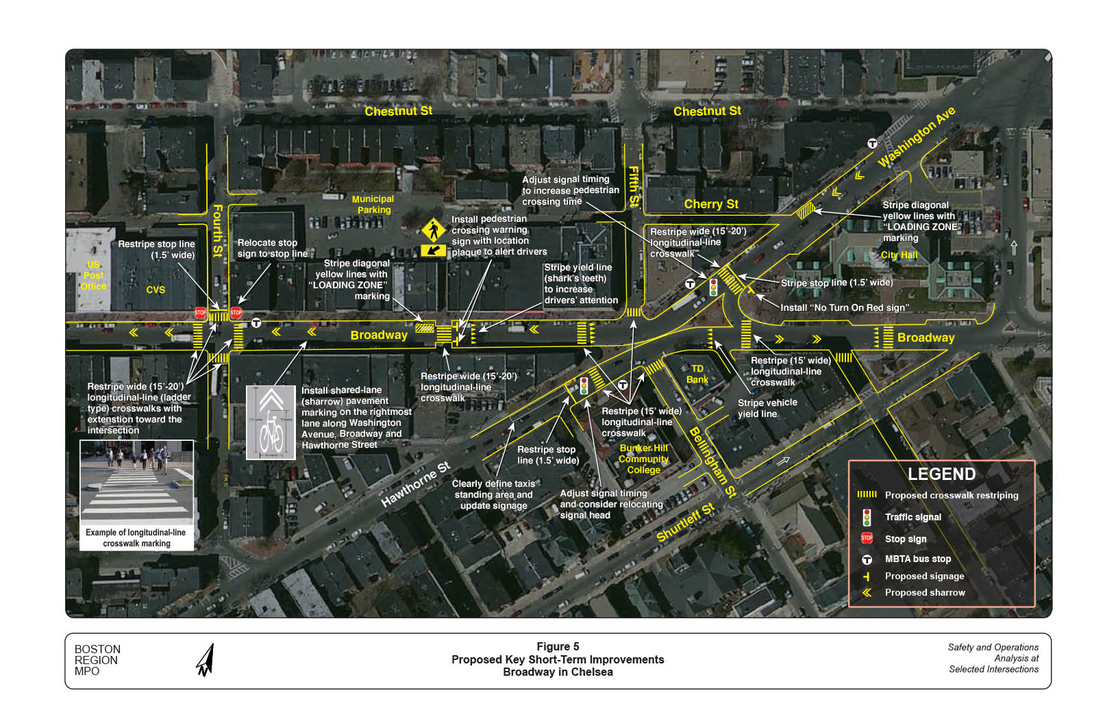
Based on the above analyses, staff developed short- and long-term improvements to address safety and operational problems. Short-term improvements may be implemented within a year at relatively low cost. Long-term improvements are more complex and generally include roadway layout modifications and major facility replacements, which would require extensive planning, design, and funding.
Figure 5 shows the proposed major short-term improvements in the study area.
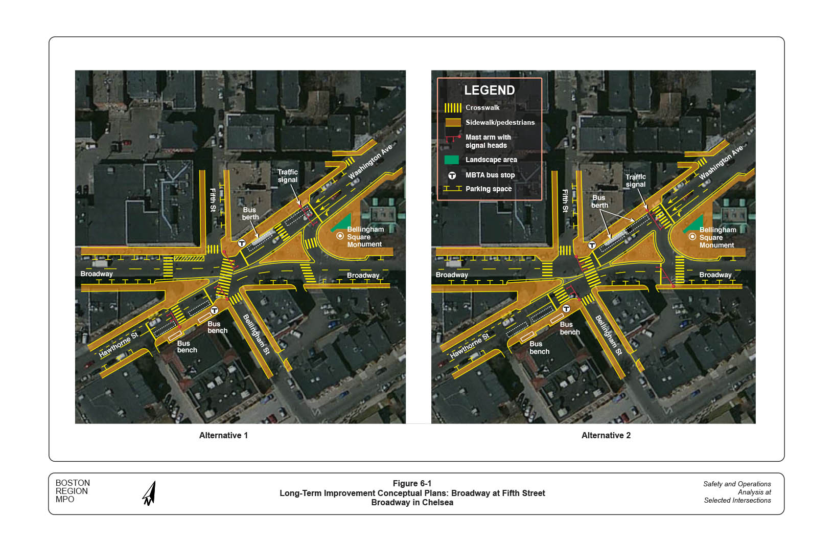
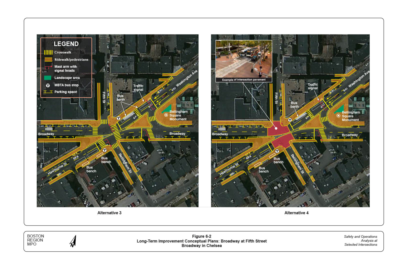
Figures 6-1 and 6-2 show conceptual plans of four long-term improvement alternatives that staff developed for the Fifth Street intersection.
Alternative 1 adds a wide crosswalk across Broadway, with new traffic and pedestrian signals, to encompass the popular but unmarked crossing area. Key elements include:
Alternative 2 provides crosswalks on all approaches at the intersection by adding and relocating crosswalks. Key elements include:
Alternative 3 is a combination of the proposed changes in Alternatives 1 and 2. It specifies crosswalks on all approaches of the intersection and shortens crossing distances by relocating the crosswalks on Washington Avenue and Broadway eastbound. Key elements include:
Alternative 4 varies slightly from Alternative 3. It combines all the crosswalks at the intersection into a major crossing area by paving the intersection block with materials that contrast with the existing roadway pavement. The key elements of this alternative are the same as for Alternative 3.
All of the alternatives would require a new traffic and pedestrian signal system that is capable of synchronizing, prioritizing, and balancing the different signal locations based on demands from pedestrians, vehicles, and even bicycles. Synchro tests of a generic setting indicate that the intersection generally would operate at desirable LOS B using the projected 2040 traffic conditions. The tested 65-second cycle length consists of a 30-second traffic phase and a 35-second pedestrian phase. Appendix K presents the signal setting and analysis results for the different peak hours (AM, PM, and Saturday).
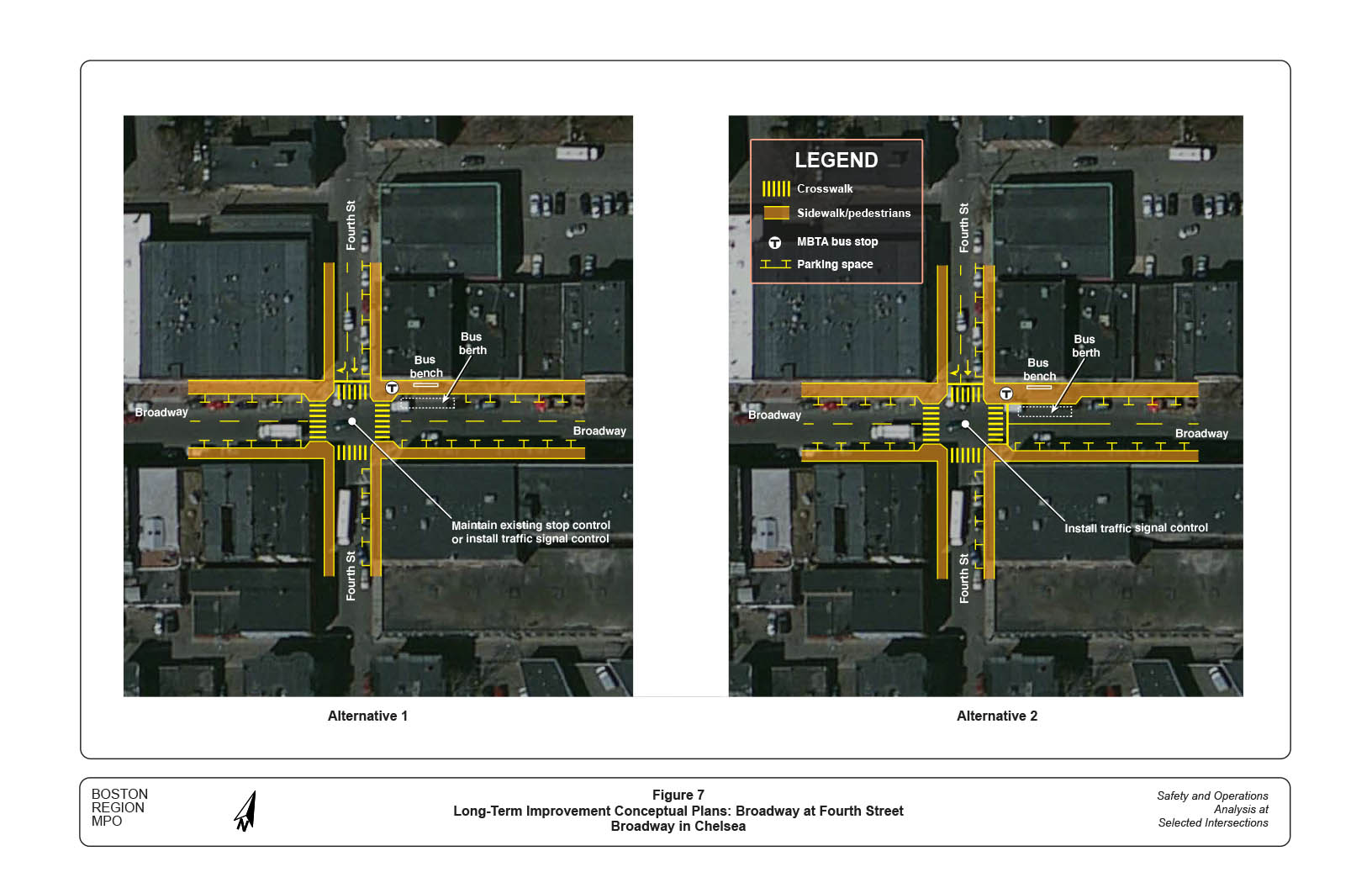
Figure 7 shows conceptual plans for two long-term improvement alternatives that staff developed for the Fourth Street intersection.
Alternative 1 proposes to extend sidewalk curbs at the four corners toward Broadway and relocate crosswalks (15 feet wide) accordingly, with ADA-compliant wheelchair ramps.10 The modification would reduce crossing distances and slow traffic on Broadway; however, it would enhance drivers and pedestrians’ views of each other significantly. The curb extension (pedestrian bulb-out) at the northeast corner also serves to prevent buses from berthing too close to the intersection. The proposed layout could be applied under the existing stop control or a new traffic signal (by adding a stop line on the Broadway westbound approach).
Alternative 2 varies slightly from Alternative 1. In addition to the curb extensions and crosswalk relocations proposed in Alternative 1, it proposes to extend the sidewalk near the bus stop to form a bus blub-out for passengers getting on and off buses. The extension also would increase space for pedestrians to traverse the bus waiting area. The proposed layout could be applied only under a traffic signal control, as drivers on Fourth Street potentially could be hindered by berthing buses.
Traffic signal control at this intersection would improve pedestrian safety and reduce delays on the Fourth Street approach significantly. The signal can operate under a 65-second cycle that consists of a 23-second traffic phase on Broadway, a 21-second traffic phase on Fourth Street, and a 21-second exclusive pedestrian phase. With careful design and no right turns on red for traffic, pedestrian crossings on the intersection’s north and east sides could operate with the Broadway and Fourth Street traffic currently. These operations, in addition to the exclusive signal phase, would provide more opportunities for pedestrians to cross the intersection. Appendix L presents the signal setting and analysis results using projected 2040 traffic conditions for the different peak hours (AM, PM, and Saturday).
This study performed a series of safety and operations analyses, identified issues, and proposed short- and long-term improvements at the two intersections and on Broadway between the intersections.
The proposed short-term improvements would enhance safety and operations for the various transportation modes used in the study area. With a high benefit/cost ratio, they should be implemented as soon as resources are available from highway maintenance or local Chapter 90 funding.
For the long term, staff recommend reconstructing the Fifth Street intersection with additional pedestrian crossings and a new traffic and pedestrian signal system that is capable of synchronizing, prioritizing, and balancing the various signal locations based on vehicular, pedestrian, and bicycle volumes. At this planning stage, staff recommend Alternatives 3 or 4. At the design stage, the City of Chelsea should examine all of the alternatives further. It would cost approximately $1,500,000 to $2,000,000 to reconstruct the Fifth Street intersection.11
Staff recommend signalizing and reconstructing the Fourth Street intersection with sidewalk extensions, crosswalk enhancements, and a bus blub-out. Staff propose two design alternatives, and prefer Alternative 2, with signalization. At the design stage, the City of Chelsea should examine the signalization requirements and the two alternatives further. It would cost approximately $500,000 to $750,000 to reconstruct and signalize the Fourth Street intersection.
For the entire study area (including downtown), staff recommend the following long-term improvement strategies:
With the advent of prospective developments, Chelsea’s historic downtown section has great potential to become a lively shopping and recreation center just north of Boston. The city recently began a multi-modal comprehensive study of all major roadways in the downtown area, which offers some foresight into major improvements that could be applicable in downtown Chelsea.
Implementing the proposed long-term improvements would require significant effort and collaboration on the part of all stakeholders, including the City of Chelsea, residents and owners of adjacent developments, MassDOT, and the MBTA. Broadway is included in National Highway System, so the city can work with MassDOT Highway Division District 6 to initiate a project, obtain a favorable review from MassDOT’s Project Review Committee, and identify potential funding resources, through both MassDOT and the Boston Region MPO.
Appendix M cites details about actions that are required in each step of MassDOT’s project development process, including a schematic timetable; further information about this process is located on MassDOT’s website, at www.massdot.state.ma.us/planning/Main/PlanningProcess/ProjectDevelopmentProcess.aspx; and at www.massdot.state.ma.us/Portals/8/docs/designGuide/CH_2_a.pdf.
CW/cw
1 Details of the selection process and criteria may be found in the Central Transportation Planning Staff’s (CTPS) technical memorandum, “Safety and Operation at Selected Intersections: Federal Fiscal Year 2016,” Seth Asante and Katrina Crocker, March 17, 2016.
2 During the counting period, Washington Avenue at the bridge over the MBTA Newburyport/Rockport Line (about 1,000 feet north of Bellingham Square) was closed for reconstruction. Through discussions with city planners, staff assumed that the closure would not cause a noticeable reduction in traffic volumes on Broadway, as drivers were able to find alternative routes to get to and from Broadway.
3 Staff used Synchro Version 9.0, developed and distributed by Trafficware Ltd. It can perform capacity analysis and traffic simulation (when combined with SimTraffic) for an individual intersection or a series of intersections in a roadway network.
4 The forecast is based on a recent MPO transportation-planning model developed for a study of the lower Mystic River area. The model indicates about 10 to 12 percent traffic growth from 2016 to 2040 for the area. Considering Silver Line Gateway Project and the potential developments in Chelsea, staff used 15 percent traffic growth for this study.
5 The estimate is based on Chapter 4E, Manual on Uniform Traffic Control Devices, 2009 Edition with Revision Numbers 1 and 2 incorporated, May 2012.
6 MassDOT Road Safety Audit: Broadway, Washington Street, Hawthorne Street, and Central Avenue, City of Chelsea, July 27, 2016.
7 The adjustment includes a slight increase of cycle length from 61 to 65 seconds and a one-second reduction from the traffic phase. Synchro tests indicated that traffic would operate at the same desirable LOS with a negligible increase in delay. This adjustment would improve pedestrians’ safety and comfort, and would have a marginal impact on traffic under the existing intersection layout and traffic conditions.
8 The restriped width can be extended from the outside edge of the existing wheelchair ramps toward the intersection.
9 Currently, the stop sign is not parallel to the one on the right, at the stop line. It also is hidden behind a utility pole, so hard for drivers approaching the intersection from the north to see.
10 The extensions might not be applicable toward Fourth Street, as they could narrow the street and become problematic for emergency vehicles.
11 This cost was estimated using general expenses of similar projects. The estimate contains only design and construction costs—not right-of-way, utility relocation, landscape and streetscape, or other contingency costs—and is based on non-inflation-adjusted 2016 dollars.
12 A number of other intersections in the downtown area have similar issues as do the intersection of Broadway at Fourth Street; so, the same proposed improvement strategies for Broadway at Fourth Street also could be considered for those.

