MEMORANDUM
DATE October 4, 2012
TO Joseph Frawley, P.E.
District 3 Traffic Engineer
MassDOT Highway Division
FROM Mark Abbott, P.E.
Boston Region MPO Staff
RE Safety and Operations Analyses at Selected Intersections, FFY 2012: Turnpike Road (Route 9) at Central Street/Oak Hill Road in Southborough
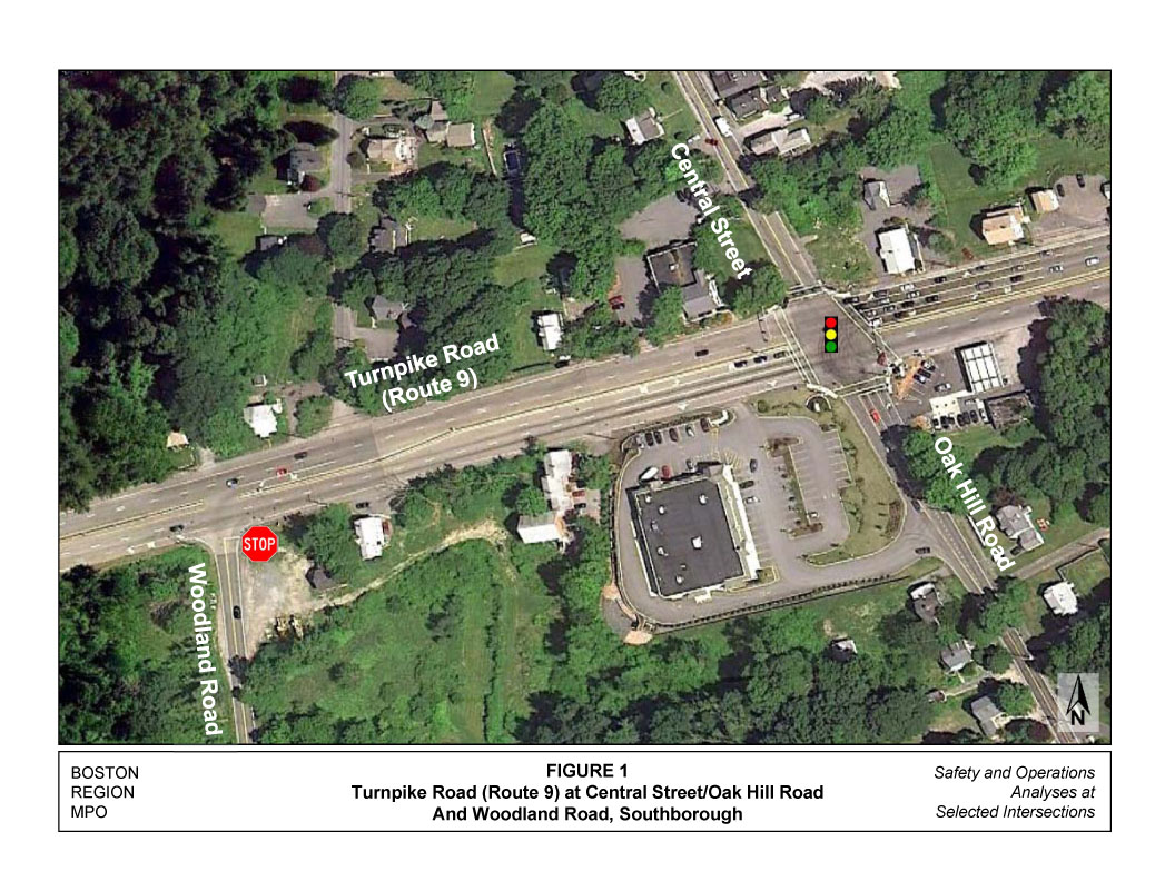
This memorandum summarizes safety and operations analyses and proposes improvement strategies for the intersections of Turnpike Road (Route 9) at Central Street/Oak Hill Road in Southborough, shown in Figure 1. It contains the following sections:
The memorandum also includes a collection of technical appendices that contain methods and data applied in the study and detailed reports of the intersection capacity analyses.
The intersection, shown in Figure 1, is owned by the Massachusetts Department of Transportation (MassDOT) Highway Division and is located in the Fayville section of Southborough. It is the easternmost Route 9 intersection in Southborough. Route 9 is under MassDOT’s jurisdiction and Central Street and Oak Hill Road are under Southborough’s jurisdiction. Route 9 is classified as a principal arterial and Central Street and Oak Hill Road are urban minor arterials.
Figure 1 also provides a view of the intersection layout and the area nearby. The lane configuration of the intersection is described below.

Traffic operations at the intersection are under fully actuated signal control, with three-phase signal operations. An exclusive pedestrian phase is provided upon activation. Route 9, in both directions, is provided with exclusive protected left-turn phases, followed by the through movements. The Central Street and Oak Hill Road approaches run concurrently.
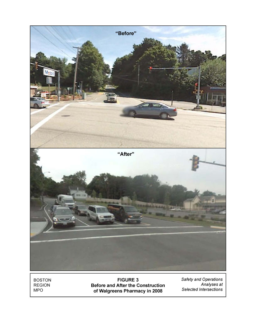
The land use at the four corners of the intersection is a mix of retail and office. In the northeast corner of the intersection, there is a small building that provides office space to several small businesses. The northwest corner of the intersection has a similar building, which also provides office space to several small businesses. The southeast corner has a Mobil gas station. In the southwest corner of the intersection is a Walgreens, which was constructed in 2008. The construction of the Walgreens store also included widening (from one to three approach lanes) of the Oak Hill Road approach to the intersection. Figures 2 and 3 provide a “before and after” look this approach. Before Walgreens was constructed, Oak Hill Road was a single-lane approach that flared at the intersection for the right turns. After it was constructed, the approach was widened to three lanes, providing an exclusive lane for each movement.
Pedestrian accommodations are provided at the intersection. There is a sidewalk along the northern side of Route 9. However, on the southern side of Route 9, there is a sidewalk only from the corner of the intersection to Walgreens store. A sidewalk is present along the eastern side of both Central Street and Oak Hill Road. The intersection has crosswalks across all four approaches, and pedestrian push buttons and signal heads are provided on each corner for crossing. An audio alert is also provided during the pedestrian phase of the signal.
The Woodland Road intersection is one of two unsignalized median breaks on Route 9 in Southborough. This three-way intersection, which has left and right turns onto Woodland Road from Route 9 and a right-turn-only lane from Woodland Road, provides access to residential properties. Woodland Road is currently the direct route for residents to and from Route 9. There is no access from Oak Hill Road; the only other access to Woodland is from Breakneck Hill Road, which is located further west.
MPO staff met with MassDOT Highway Division District 3 personnel to discuss their concerns about the intersection. MassDOT’s concerns and comments received from the public deal with the problem of congestion during the peak periods in the morning and afternoon commuting hours. This intersection is near several office developments, both in Southborough and Framingham, as well as near the Mass Turnpike Framingham interchange.
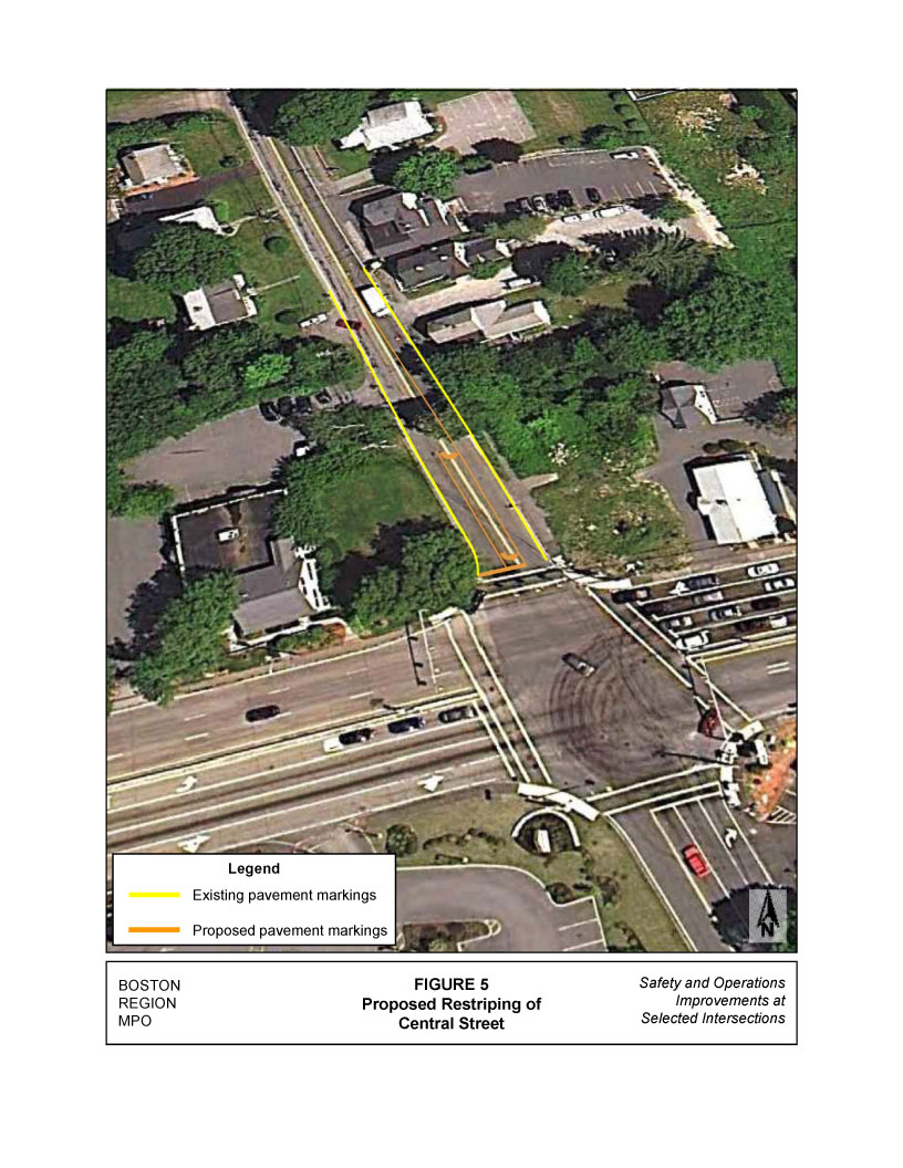
In addition to the congestion concerns, there appears to be some driver confusion related to the lane assignments on the southbound Central Street approach. Even though the approach is striped as a single lane, there is sufficient width to allow vehicles to queue side by side in the single lane, making a de facto two-lane approach. However, the lane assignments were not clear to drivers—staff repeatedly observed two vehicles making the same through movement to Oak Hill Road, narrowly avoiding side-swipe crashes.
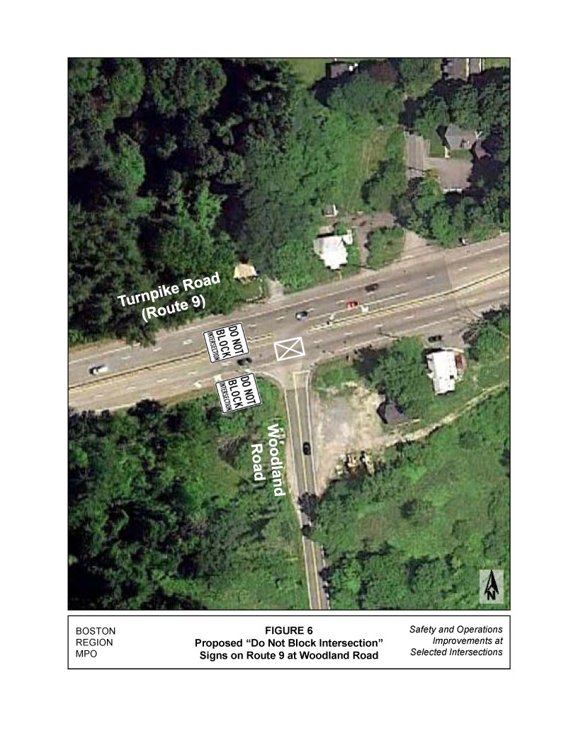
Another issue that MassDOT brought up in the discussion was the median break and access to Woodland Road, located approximately 770 feet west of the Central Street/Oak Hill Road intersection. Eastbound queuing during the AM peak hour consistently extends past Woodland Road. MassDOT was interested in finding out if this intersection affects the operations of the Central Street/Oak Hill Road intersection and if it is a dangerous situation that needs to be improved.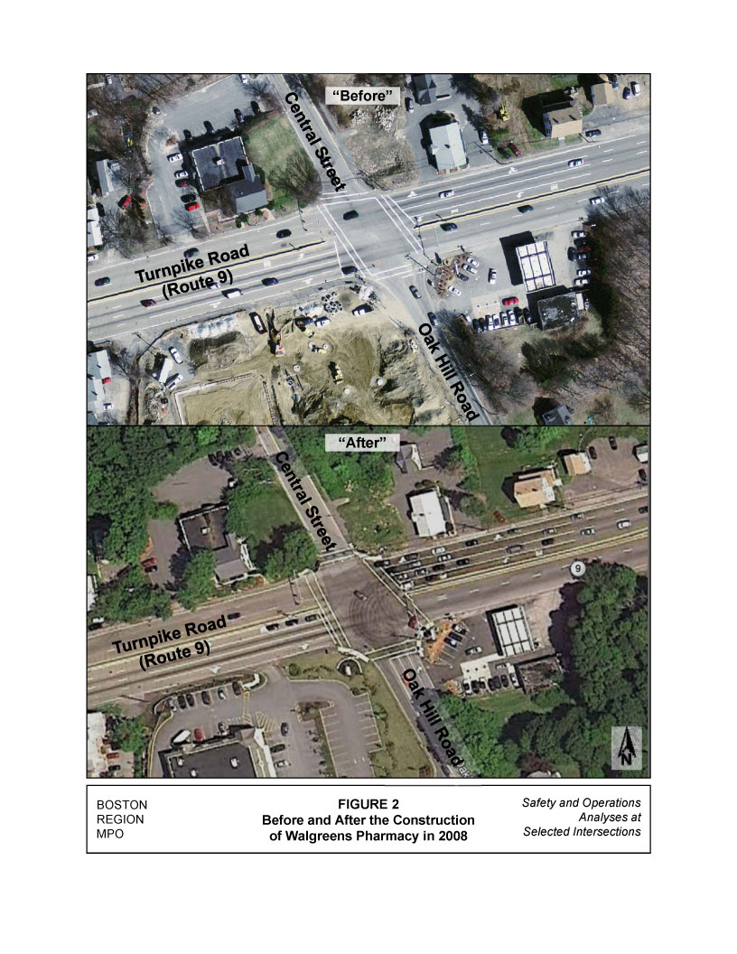
Staff collected crash data from the MassDOT Registry of Motor Vehicles Division for the most recent five years available, 2005 to 2009. Tables 1 and 2 provide a summary of the crashes at the Central Street/Oak Hill Road intersection and the Woodland Road intersection, respectively, for the most recent five years.
An average of 16 crashes occurred at the Central Street/Oak Hill Road intersection each year. In total, about 70 percent of the crashes resulted in property damage only, and 22 percent in personal injuries. However in one of the reported crashes, a fatality occurred. The fatality, which occurred in the spring of 2009, involved a pedestrian and single vehicle and occurred at 10:00 PM; no other information about weather conditions, pavement conditions, or lighting was reported. The majority of the collision types were rear-end collisions (50 percent), followed by angle collisions (22 percent); both collision types are common at signalized intersections. There were no crashes that involved cyclists in that period.
A total of 32 crashes occurred on the Woodland Road intersection for the same five-year period, averaging just over six crashes a year. Over half of the crashes (56 percent) were classified as property damage only, with only 15 percent involving personal injury. Based on the crash data, 44 percent of the collision types were angle crashes, the majority of which involved Route 9 westbound vehicles turning left onto Woodland Road, and a few crashes involved vehicles that were exiting from Woodland Road to turn onto Route 9 eastbound. Many of these crashes occurred during peak periods (7:00 to 9:00 AM and 4:00 to 6:00 PM), when Route 9 traffic is at or near its peak.
Crash rate is another effective tool for examining the relative safety of a particular location.1 Based on the 2005–09 crash data and the recently collected (in 2012) traffic volume data, the crash rate for the Central Street/Oak Hill Road intersection is 0.76 (see Appendix A for MassDOT intersection crash rate worksheets). The crash rate at the intersection is less than the average rate for signalized intersections in MassDOT Highway Division District 3, which is estimated to be 0.90 crashes per million entering vehicles. The crash rate for the Woodland Road intersection is 0.33, which is also below the District 3 average for unsignalized intersections— 0.66 crashes per million entering vehicles.
TABLE 1
Summary of MassDOT Crash Data (2005–09):
Turnpike Road (Route 9) at Central Street/Oak Hill Road
|
|
|
|
|
|
|
2005–09 |
||
|
2005 |
2006 |
2007 |
2008 |
2009 |
|
Total |
Average |
|
Total Number of Crashes |
12 |
17 |
14 |
21 |
18 |
|
82 |
16.4 |
|
Crash Severity |
Property damage Only |
9 |
9 |
11 |
16 |
12 |
|
57 |
11.4 |
Personal injury |
2 |
5 |
1 |
4 |
5 |
|
17 |
3.4 |
|
Fatality |
0 |
0 |
0 |
0 |
1 |
|
1 |
0.2 |
|
Not reported |
1 |
3 |
2 |
1 |
0 |
|
7 |
1.4 |
|
Collision Type |
Angle |
3 |
2 |
4 |
5 |
4 |
|
18 |
3.6 |
Rear-end |
8 |
11 |
3 |
9 |
10 |
|
41 |
8.2 |
|
Sideswipe |
0 |
2 |
3 |
4 |
2 |
|
11 |
2.2 |
|
Head-on |
0 |
0 |
0 |
0 |
0 |
|
0 |
0.0 |
|
Single vehicle |
0 |
1 |
4 |
1 |
2 |
|
8 |
1.6 |
|
Not reported |
1 |
1 |
0 |
2 |
0 |
|
4 |
0.8 |
|
Roadway Conditions |
Wet or icy pavement |
2 |
7 |
3 |
3 |
5 |
|
20 |
4.0 |
Dark/lighted |
2 |
5 |
6 |
2 |
4 |
|
19 |
3.8 |
|
Weather Conditions |
Clear |
11 |
11 |
7 |
15 |
9 |
|
53 |
10.6 |
Cloudy |
1 |
3 |
4 |
4 |
4 |
|
16 |
3.2 |
|
Rain |
0 |
2 |
2 |
1 |
3 |
|
8 |
1.6 |
|
Snow |
0 |
1 |
1 |
1 |
1 |
|
4 |
0.8 |
|
Crashes during weekday peak periods* |
8 |
6 |
5 |
12 |
5 |
|
36 |
7.2 |
|
Crashes involving pedestrian(s) |
0 |
0 |
0 |
0 |
1 |
|
1 |
0.2 |
|
Crashes involving bicyclist(s) |
0 |
0 |
0 |
0 |
0 |
|
0 |
0.0 |
|
* Peak periods are defined as 7:00–10:00 AM and 3:30–6:30 PM.
TABLE 2
Summary of MassDOT Crash Data (2005–09):
Turnpike Road (Route 9) at Woodland Road
|
|
|
|
|
|
|
2005–09 |
||
|
2005 |
2006 |
2007 |
2008 |
2009 |
|
Total |
Average |
|
Total Number of Crashes |
10 |
8 |
5 |
6 |
3 |
|
32 |
6.4 |
|
Crash Severity |
Property damage Only |
6 |
5 |
2 |
2 |
3 |
|
18 |
3.6 |
Personal injury |
2 |
1 |
2 |
0 |
0 |
|
5 |
1.0 |
|
Fatality |
0 |
0 |
0 |
0 |
0 |
|
0 |
0.0 |
|
Not reported |
2 |
2 |
1 |
4 |
0 |
|
9 |
1.8 |
|
Collision Type |
Angle |
3 |
5 |
2 |
2 |
2 |
|
14 |
2.8 |
Rear-end |
4 |
2 |
3 |
2 |
1 |
|
12 |
2.4 |
|
Sideswipe |
1 |
0 |
0 |
1 |
0 |
|
2 |
0.4 |
|
Head-on |
0 |
0 |
0 |
0 |
0 |
|
0 |
0.0 |
|
Single vehicle |
2 |
1 |
0 |
1 |
0 |
|
4 |
0.8 |
|
Not reported |
0 |
0 |
0 |
0 |
0 |
|
0 |
0.8 |
|
Roadway Conditions |
Wet or icy pavement |
6 |
2 |
1 |
3 |
1 |
|
13 |
2.6 |
Dark/lighted |
2 |
1 |
1 |
3 |
0 |
|
7 |
1.4 |
|
Weather Conditions |
Clear |
4 |
5 |
4 |
3 |
2 |
|
18 |
3.6 |
Cloudy |
1 |
1 |
0 |
1 |
0 |
|
3 |
0.6 |
|
Rain |
3 |
2 |
1 |
2 |
0 |
|
8 |
1.6 |
|
Snow |
2 |
0 |
0 |
0 |
1 |
|
3 |
0.6 |
|
Crashes during weekday peak periods* |
4 |
3 |
3 |
5 |
2 |
|
17 |
3.4 |
|
Crashes involving pedestrian(s) |
0 |
0 |
0 |
0 |
0 |
|
0 |
0.0 |
|
Crashes involving bicyclist(s) |
0 |
0 |
0 |
0 |
0 |
|
0 |
0.0 |
|
* Peak periods are defined as 7:00–10:00 AM and 3:30–6:30 PM.
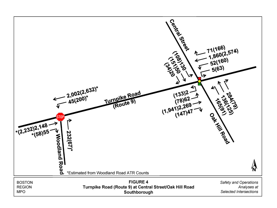
MPO staff collected turning-movement counts (TMC) at the intersection on March 2 and 22, 2012. The data were recorded in 15-minute intervals for the peak traffic periods in the morning, from 7:00 to 9:00 AM, and in the evening, from 4:00 to 6:00 PM. The peak hours occurred between 7:45 and 8:45 AM and between 4:45 and 5:45 PM. The peak-hour traffic volumes are shown in Figure 4.
The only pedestrian activity occurred during the PM peak period, when three pedestrians were observed crossing Route 9 from the Walgreens store to the northern side of the intersection.
In addition to the pedestrian counts, MassDOT provided automated traffic recorder (ATR) counts for the study area between March 12, 2012, and March 15, 2012. These counts were used to estimate the turning volumes at the Woodland Road intersection.
The ATR count data are provided in Appendix B, and TMC count data are provided in Appendix C.
Based on the turning-movement counts and the signal timing data provided by MassDOT District 3, the intersection capacity and operations were analyzed using an intersection analysis program, Synchro.2 The existing conditions analysis for the AM and PM peak hours is provided in Table 3.
2012 Intersection Analysis
|
|
|
|
AM Peak Hour |
|
PM Peak Hour |
||||||
|---|---|---|---|---|---|---|---|---|---|---|---|
| Approach |
Mvmt |
|
LOS |
Delay1 |
V/C2 |
Q3 |
|
LOS |
Delay1 |
V/C2 |
Q3 |
Existing Conditions |
|||||||||||
Route 9 – EB |
U4L |
|
D |
54.4 |
0.54 |
98 |
|
f |
169.4 |
1.17 |
333 |
|
TR |
|
c |
27.3 |
0.87 |
695 |
|
c |
24.6 |
0.82 |
605 |
Route 9 – WB |
U4L |
|
E |
58.3 |
0.57 |
83 |
|
f |
189.5 |
1.22 |
412 |
|
TR |
|
C |
25.3 |
0.80 |
573 |
|
e |
72.2 |
1.08 |
1106 |
Oak Hill Road – NB |
L |
|
E |
60.6 |
0.81 |
209 |
|
f |
108.2 |
0.92 |
172 |
|
T |
|
D |
40.7 |
0.38 |
165 |
|
D |
49.7 |
0.50 |
168 |
|
R |
|
D |
38.9 |
0.21 |
66 |
|
D |
45.1 |
0.06 |
38 |
Central Street – SB |
L5 |
|
D |
48.0 |
0.63 |
175 |
|
e |
66.8 |
0.74 |
186 |
|
TR |
|
d |
39.4 |
0.25 |
96 |
|
e |
64.8 |
0.78 |
279 |
Overall |
|
|
C |
30.5 |
0.79 |
- |
|
e |
63.2 |
1.07 |
- |
Signal Timing Optimization |
|||||||||||
Route 9 – EB |
U4L |
|
E |
62.0 |
0.68 |
95 |
|
f |
144.1 |
0.53 |
294 |
|
TR |
|
c |
21.6 |
0.83 |
542 |
|
c |
30.1 |
0.90 |
600 |
Route 9 – WB |
U4L |
|
f |
102.1 |
0.85 |
101 |
|
f |
132.5 |
0.48 |
348 |
|
TR |
|
C |
20.9 |
0.77 |
465 |
|
f |
112.4 |
0.81 |
1036 |
Oak Hill Road – NB |
L |
|
E |
71.5 |
0.88 |
213 |
|
E |
58.3 |
0.80 |
133 |
|
T |
|
D |
39.4 |
0.41 |
155 |
|
D |
41.4 |
0.37 |
147 |
|
R |
|
D |
37.3 |
0.21 |
65 |
|
D |
37.7 |
0.21 |
36 |
Central Street – SB |
L6 |
|
D |
49.2 |
0.68 |
174 |
|
D |
47.9 |
0.62 |
142 |
|
TR |
|
d |
37.9 |
0.27 |
90 |
|
d |
50.3 |
0.25 |
231 |
Overall |
|
|
C |
27.5 |
0.85 |
- |
|
e |
78.6 |
1.01 |
- |
1 Delay in seconds per vehicle.
2 V/C is the volume-to-capacity ratio.
3 95% queue in feet.
4 U-turn movements.
5 De facto left-turn lane.
6 Analyzed with dedicated left-turn lane.
Discussions with District 3 personnel and analysis of the intersection led to the determination that no major improvements for the intersection could be justified. Signal visibility is adequate, with signal heads located overhead on mast arms, and pedestrian accommodations are provided for the few pedestrians present. Existing signage is adequate for Route 9 and the side streets. As mentioned previously, the intersection was partially reconstructed during the construction of the Walgreens store, when the Oak Hill Road approach to the intersection was widened to three approach lanes.
During the study, the following potential safety and operations improvements were analyzed:
The best results of the optimization of the signal timings for the AM and PM peak hours are shown in Table 3. These results indicate that a slight improvement for the Central Street and Oak Hill Road approaches can be accomplished at the expense of the Route 9 operations. Results of the protected/permitted-left-turn phasing and phase times for Central Street and Oak Hill Road did not improve overall operations of the intersection or the operations for the side streets.
Central Street/Oak Hill Road Intersection
The above safety and operations analyses indicate that the only significant improvement to the intersection that is recommended is the restriping of the Central Street approach. Staff observed vehicles continually using the wide approach as two lanes, with the left lane predominately used by left-turning vehicles. However, occasionally a through vehicle would line up in the left lane and make the through movement with a vehicle lined up in the right lane, nearly causing a side-swipe crash, since there is only a single departure lane on Oak Hill Road.
The recommendation is to provide two delineated approach lanes. There is currently about 33 feet of total roadway width available to accommodate the proposed lanes. The existing double yellow center line would need to be removed and replaced to allow the following new proposed lane widths:
The optimization of the timings, protected/permitted phasing, and split phasing are not recommended. As shown in Table 3, the signal timing optimization does not improve the overall operations (in the simulation). Slight improvement is shown for the Central Street and Oak Hill Road approaches, but it there are increased delays on Route 9. The same problem occurs when the protected/permitted phasing and split phasing operations are simulated.
During the peak periods, it was observed that the Route 9 eastbound queue regularly backs up to and through the Woodland Road intersection. However, this does not seem to affect the operations of the Central Street/Oak Hill Road intersection. The safety analysis of the Woodland Road intersection indicates that this intersection has a crash rate of 0.33, which is half the average rate for District 3 unsignalized intersections, despite the high Route 9 traffic volumes. It was also observed that queuing Route 9 eastbound vehicles regularly provided gaps for both Route 9 westbound left-turning vehicles and for the right turns from Woodland Road.
However, to ensure that gaps exist for turning vehicles, it is recommended that a “Do Not Block Intersection” box and signage be installed on the eastbound side of Route 9. In addition, if this results in an increase in the number of crashes or personal injury crashes in the future, after the proposed improvement, the possibilities of closing the median and prohibiting left-turns onto Woodland Road from Route 9 westbound must be considered.
MA/ma
1 Crash rates are estimated based on crash frequency (crashes per year) and vehicle exposure (traffic volumes or miles traveled). Crash rates are expressed as “crashes per million entering vehicles” for intersection locations and as “crashes per million miles traveled” for roadway segments.
2 Synchro Version 7 was used for these analyses. This software is developed and distributed by Trafficware Ltd. It can perform capacity analysis and traffic simulation (when combined with SimTraffic) for an individual intersection or a series of intersections.